Leaderboard
Popular Content
Showing content with the highest reputation since 12/15/15 in all areas
-

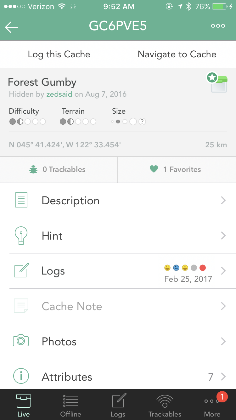
Support for Apple Carplay
burgerre and 5 others reacted to Nic Hubbard for a question
We are hoping to include CarPlay support in 8.1.6 points -
Cachly 4 crashes updating list
ACME WildCachers and 5 others reacted to Nic Hubbard for a topic
This is painfully slow. I am rewriting the entire interface and background downloading for updating caches. This will be in the next beta. I tested updating 1,000 full caches and got the following: Basic Update: 3.8 seconds Full Update: 39.8 seconds It has been a while since I revisited the old code that is currently downloading/updating caches so it was time for a rewrite.6 points -
Easy mark locations
afishoutawater and 4 others reacted to Nic Hubbard for a question
Yes. I will add a feature where you can tap the current location and create a waypoint from that.5 points -
I'm sure it's been asked before, but wondering how far down the development tree is the ability to have multiple log templates. Or ideally, a seperate template for each log type (Find, dnf, need maintenance etc) this would be really handy.5 points
-

Cachly 2.1 unified database
Btwchen and 4 others reacted to vanBaarsel for a question
A little off topic, but I guess there are a lot of "refugees" using Cachly! Great to see an active developer again5 points -
To expand a bit, Geosphere has the ability to display the proximity circles as an overlay on the map, and it's also set to only show on physical waypoints - posted coordinates for physical cache types, and multi-stage and final waypoints. (reference points, parking/trailhead/virtual etc are not relevant for proximity concerns and so don't show the circle). It's a very useful feature, especially when planning for cache placement in a busier area.5 points
-
Voting for Feature Requests
geomonden and 4 others reacted to Nic Hubbard for a question
You can now vote for feature requests. This will help us to know how popular suggested features might be. Please vote!5 points -

Add compass to map screen for easier navigation
geoBirder and 3 others reacted to PlasmaWave for a question
FEATURE REQUEST: Add a small semi-transparent compass to top corner of map screen when navigating to a cache or waypoint. We have discussed this before ... see "Looking4Cache" method - preferably, like L4C, the compass would be user selectable: 1. show or hide 2. small or larger 3. adjust level of transparency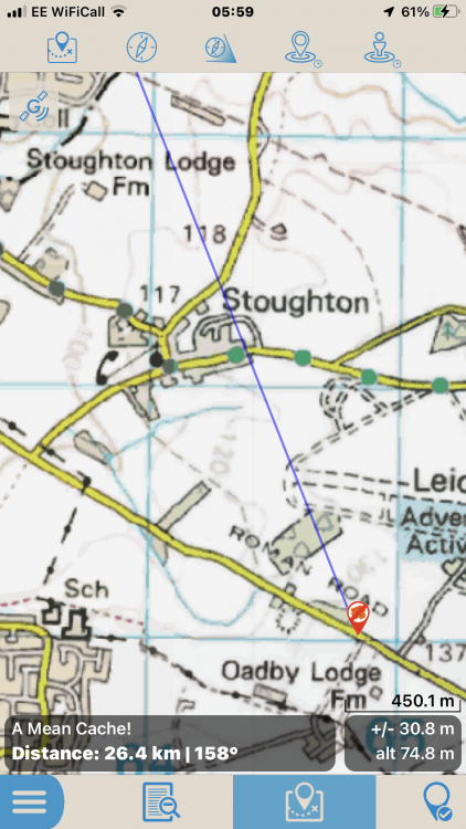
 4 points
 -
Hello, just wondering if there would be any possibility for cachly or navigation to a cache to be able to be connected to the Apple CarPlay I asked on Facebook page also and a couple of others like the thought of it too. Would it be at all possible? Thanks in advance for your time and considerations regards Maattmoo4 points
-
Copy Options
PlasmaWave and 3 others reacted to Nic Hubbard for a question
This can be done on the Additional Information screen. If you tap on a row of information it will save to the clipboard. Then, if you long press on another row, it will append that text to the previously copied text. I realize this could be useful, but I also think that users would be annoyed if it showed the share sheet every time they were only wanting to copy the text.4 points -
Cachly on Apple CarPlay
nastrud and 3 others reacted to Nic Hubbard for a question
I would be interested in building this. I put in an application for the CarPlay program to Apple probably a year ago, but have not hear back. You can’t even start development without approval and some special files they provide.4 points -
Alert when approching a cache
tonamigon and 3 others reacted to stealthcat for a question
A nice feature would be an alert when getting in a specified range of an cache. This might be very usefull when hiking a cache trail without having to watch the display all the time.4 points -
Power Trail Caching
ChrisDen and 3 others reacted to Nic Hubbard for a question
Instead of cluttering up the map callout, I think this would be an excellent use for our 3D/force touch feature. So you would be able to hard press on the map callout to show these additional options. Would that help?4 points -
Navigating to waypoint - others visible
Bolling and 3 others reacted to Nic Hubbard for a question
I will add this feature hopefully in the next beta.4 points -
Loading offline caches
barefootguru and 3 others reacted to Nic Hubbard for a topic
In a future version there will be an option to choose the Offline List to import your PQ info.4 points -
I have a number of trackables items I carry with me, and would love to be able to set these up as part of a Template, so when I log a find I don’t have to also select each TB I want to dip. Obviously this wouldn’t apply to Drops. This would save a LOT of time on Big Logging Days.4 points
-
Multiple offline lists active at once
barefootguru and 3 others reacted to Nic Hubbard for a question
Thanks. This is something that we have on the list for a future version.4 points -
I believe the ability to have multiple offline lists selected at once is in the plans. The other side of that coin is needed. The ability during "Add to Offline List" to select multiple offline lists to add a cache to. For example, a solved puzzle might go on the solved list and also on the East Bay list to make it show up when I'm caching in that area and on a third list if it has a DT combo I need for my grid. Adding to multiple lists and using multiple lists are independent features and could be implemented independently.4 points
-
Daily Cache Found Count and Total Count Display
Echo and 3 others reacted to CaptainMath for a question
I see this was sort of, or accidentally, requested by someone in another thread here, but since it looks like it's not what the original poster asked for in his thread, I'll go ahead and post here. I'd love to see cachly make a count of my total number of finds in the current day easy to display, perhaps along with a list of all caches logged or with logs pending in the current day.4 points -
Cache Note Template
Bolling and 3 others reacted to Nic Hubbard for a question
I would think a simple insert feature would work here. Such as an option to insert the current date, your username, etc etc. Keywords wouldn't work since they would need to be replaced before synching with geocaching.com.4 points -
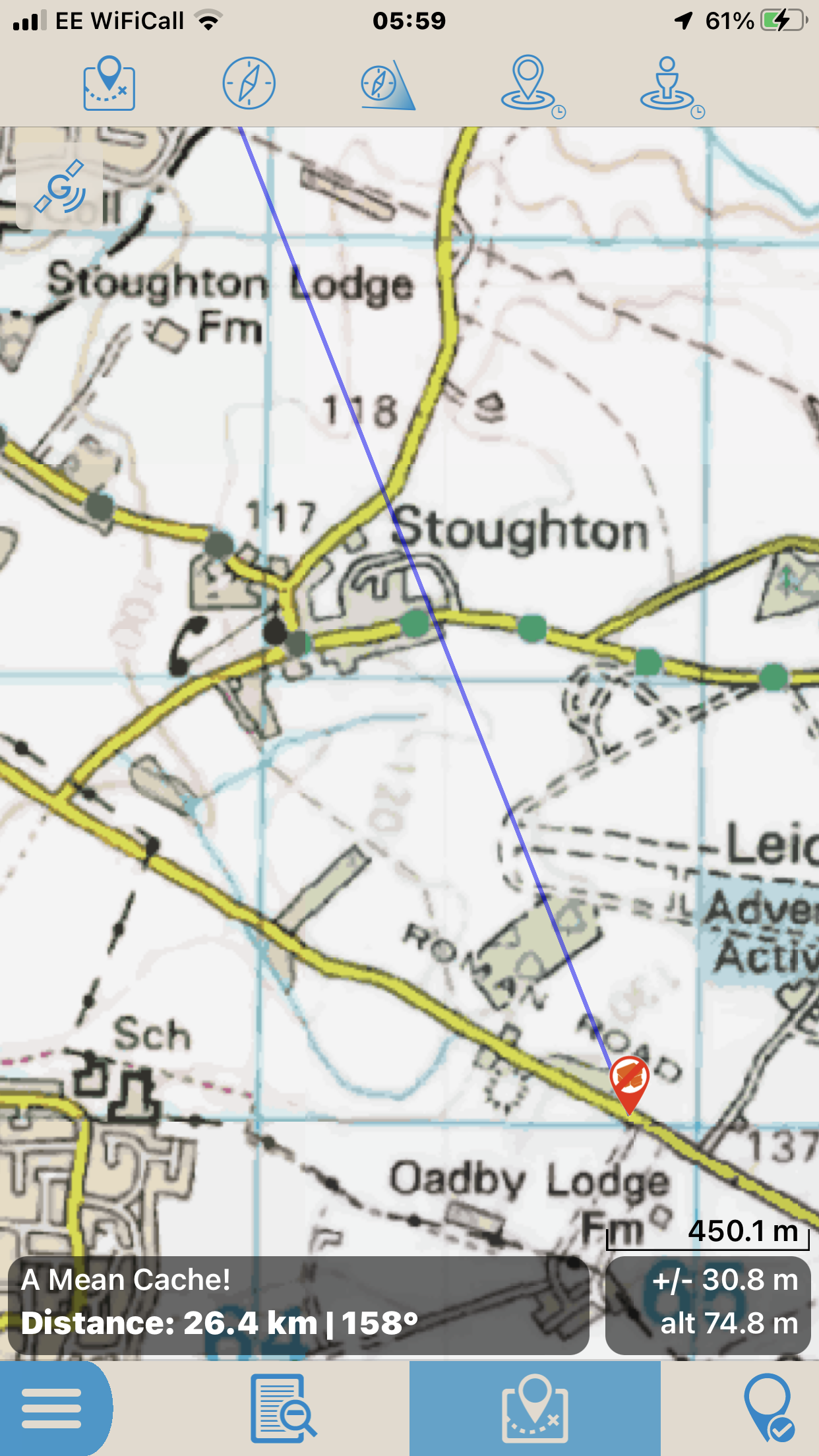
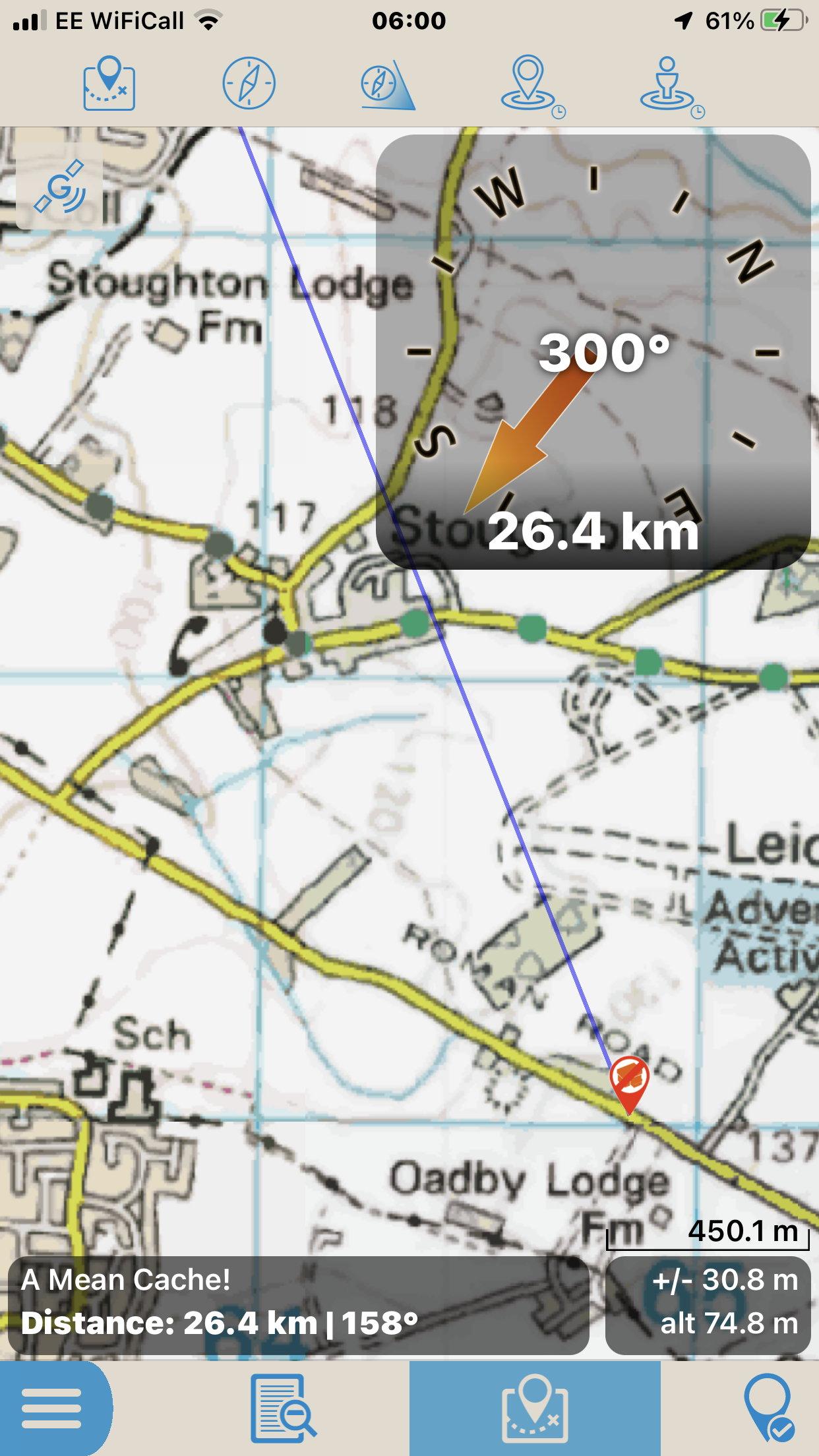
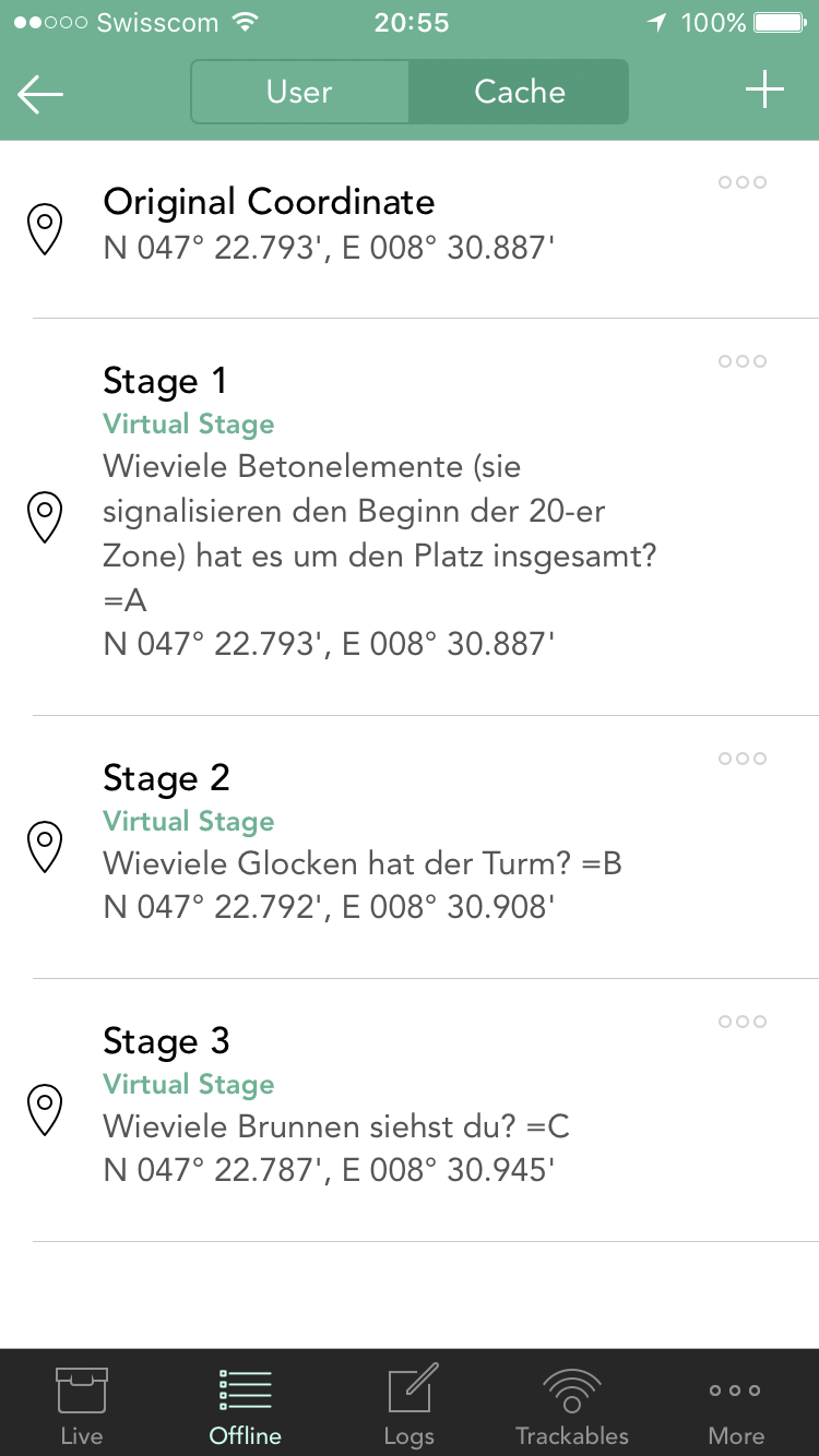
Hi Nic I would be great if the waypoint details (description) would be visible in the 'Navigate to Cache' mode. This cache for example has the following waypoints with a task you have to solve at each waypoint (counting things in this case): But in the 'Navigate to Cache' mode I can't see what I have to do at a certain waypoint, e.g. 'Stage 1': So I have to switch back to the cache detail page and lookup the task of the waypoint. Seeing the waypoint description directly in the 'Navigate to Cache' mode would be much easier And the killer feature would be that I could see the waypoints not only in the 'Navigate to Cache' mode, but already in the normal map view of an offline list (switchable on/off). With this feature I could see on the map if I walk past a waypoint of a multi cache where I have to do something, while going to get a traditional cache Or even planning the optimal route to solve several multis at the same time Thanks for your great work and best regards Michael

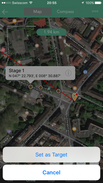 4 points
 -
Log icons on map popup
fancypants and 3 others reacted to Nic Hubbard for a question
I do have this on our list for offline lists. Just need to design how it would look.4 points -
Breaking news. Public outcry has saved email.4 points
-
Open cache from pending logs
ThePinkTeaspoon and 3 others reacted to Ketil for a question
Hi, Thanks for creating the best geocaching app out there. I often save finds while in the field, and then compose and submit the logs when I get home. What would really be a good feature for this workflow, is the ability to return to the cache listing from the pending log view. Today, I have to search for the cache ID to find it, which is a bit cumbersome. I typically do this to read through the description to get input on my log, and for mysteries I like to have a look at my cache notes to see when I solved it, etc. Kind regards, Ketil4 points -

Allow long press on log filter
Bolling and 2 others reacted to barefootguru for a question
Cachly 8 introduced a long press on the map filter to quickly enable/disable the filters. Would be cool/consistent to have this for the log filtering as well.3 points -
Having to pay again for the new version?
barefootguru and 2 others reacted to markens for a topic
Another voice in support of the developer. I paid for the cachly app early on (2017). I paid for map downloads (2019). I received tremendous value in return for those purchases of relatively trivial amounts. I've actually been wondering how Nic can continue his excellent support of this app which I use daily, without additional revenue. So I welcome being able to help via the new subscription. The $15/year pro subscription is a no-brainer in my mind, even though I won't be using some of the included features. The $5/year map subscription is even more of a value. I love what cachly helps me do and want it to continue!3 points -
I wonder if support for Apple Carplay is in the works for Cachly.3 points
-
Mapy.cz integration for navigation
Hodějovice and 2 others reacted to Nic Hubbard for a question
Yes, this has been added in our 8.0 version which is in development.3 points -
Hmm, OK, but if I can express my feelings, I have always filtered out T5 caches, I don't do them. And if I disable terrain filter, I can see labs, but also, I see lot of caches, which I can't grab. It would be nice if I can show labs and also, do terrain filter. I mean, why remove labs, when filter is applied? I understand, they does not have terrain rating, but if someone want to hide them, there is switch for it. So, my idea is: show them always and if someone don't want to see them, there is already button for it... BTW: lab stages are the best function I have ever seen! Thanks!3 points
-
Quick display waypoints
PlasmaWave and 2 others reacted to Nic Hubbard for a question
In a future version you will be able to see all waypoints on the map, so this should help.3 points -
I’ve been finding the Cachly Apple Watch app very handy recently for kayak caching. Handy to see distance to next cache by simply turning my wrist instead of reaching for my phone while paddling. I just picked up an Apple Watch 4 & realized with the extra screen space there is a bunch more info Cachly could possibly show. It would be super nice to have a distance & maybe even small compass or general direction to next cache complication. Would be killer for kayak caching and come to think of it sorta was what I was looking for with regards to power trail caching. Even if that isn’t possible at the very least it would be nice if the Cachly watch complication was able to be used in more of the faces. Keep having to use a very specific face just so it’s available to use via the main face. It’s kinda funny how what at first I thought was just a cool gimmicky thing to use every once in awhile has become a real time saver that has a bunch of potential.3 points
-
Change filter Icon to RED when active
Vertumnis and 2 others reacted to Nic Hubbard for a question
In 5.0 I am making it very obvious that filtering is turned on: You will also be able to tap the label to access the filtering options.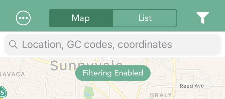 3 points
 -
Google has done a nice job of indexing the wiki content for anyone that searches without coming to the wiki first. My testing shows Google returning forum hits first (all grouped in the top search result) and then the most relevant Wiki pages. If people search for answers to their questions (a big IF), the effort put into the Wiki should definitely pay off. Nice job all!3 points
-
Once you have the final coordinates, add them as a waypoint and tap the Is Corrected Coordinate button. Save the waypoint. There will now be a red triangle on top of the cache icon so you can spot it. However, in Live view, the Geocaching.com API only returns caches based on published coordinates. You will still see the red triangle but only if the published Coords land in your search area. The displayed position will reflect the solved location. Offline lists always show the final Coords. I keep an offline list named "Solved" where I save all solved mystery caches. I can examine it and see what is in my Tour area easily.3 points
-
A third party developer doesn't have access to the Groundspeak databases to be able to check that the entered coordinate is correct for any of the existing caches. If you could just make an API call to get the final location of a cache, then puzzles wouldn't be much of a challenge at all. For any new caches, having cachly being the only way to check a coordinate restricts too much of the population of cachers (all those that don't have an Apple device), so there wouldn't be any point in doing this either and excluding the majority of the geocaching community. With many checkers already in existence (Geochecker, Geocheck, Certitude, or Groundspeak's own one), there are plenty of existing checkers for a CO to chose from, and not a lot of point in @Nic Hubbard spending time developing yet another one, taking his time away from fixing other more important things with the app which benefit a greater proportion of the Cachly users.3 points
-
1] Is to possible to have more than one, i.e., several, Offline List active at the same time? Sometimes, when I'm caching I will be looking for caches in, e.g. "DT-Davis" but caching very near it's border with "DT-Sacramento." It would be useful to be able to have them both active as had been the case in the days of Geosphere. 2] After updating my Offline List information on GSAK I want to be able to upload the caches to the appropriate Offline List. Is there a way to empty the appropriate list or must I delete the list and it's title and add a new list with the old title before uploading? I'm sure you, Nick, are tired of hearing this but this was possible in Geosphere. I do appreciate that Cachly was already available when Geosphere bit the dust and am slowly getting up to speed. It's that old dog ... new trick problem rearing it's ugly head once again.3 points
-
I dithered on my opinions on this one earlier. Having hiked for a 54 stage multi yesterday, I keenly felt the inability to spot other caches along the way to the next waypoint. Overall map view did not show the next waypoint of the multi and what opportunities might lie along the way. Getting back to the original multi to plot the current waypoint after diverting to find a nearby cache was not easy. I think what would have served is a setting on global map view to you show all waypoints a way to highlight a waypoint so I could spot the currently sought one quickly in map view with context about what was nearby on the way to it. This suggests waypoints could have a small set of associated data like highlight and a note field to record info for multi step field puzzles Better coupling of a displayed Waypoint to its cache. E.g. Option on Waypoint press to open the waypoints screen of the parent to see it and other waypoints. I should be able to get from a waypoint to the parent Cache to do things like see the description, hint, etc. This becomes more important with all waypoints shown on map as it also helps to determine the cache the WP belongs to. Sorry if this wandered off off into a longish list of Waypoint features but each step seemed to open up further needs.3 points
-
I've always wanted to be able to see the waypoints that belong to another (possibly distant) cache on the map, when I'm looking at the area the waypoint is in, not just when I'm looking at that cache. Here's an example. There's a cache in my area that has it's published coordinates "downtown", but it has published waypoints scattered all over the county, many miles apart. Last weekend I was caching in a park that had one of the waypoints, but of course I couldn't see it. I missed a TCO (Tree Climbing Opportunity). Ultimately, I'd like to be able to say to the map "show me all the geocaching stuff in this park, caches and waypoints". Of course, this should include published waypoints as well as "user waypoints" I've added (while working on a large multi, for example) I realize this would take a lot of churning through data to achieve, so I was thinking there could be a list I could designate as one that would include the "distant caches" I'd always want to see in this view. This feature would make my geocaching life complete.3 points
-
Recently I started to use the saved locations feature and it is really very useful. It would be very nice if the saved locations would be shown on the map when loading an offline list. Currently the locations are shown after I saved them, but when I switch from one offline list to another the saved location pins are gone. I have to select a saved location to see it, but I only see one at a time and nothing else. With all saved locations visible on the offline map, I could easily see all my markers for hotels, restaurants and bars while caching Best regards Michael3 points
-

Dropped Pin Radius
kojy and 2 others reacted to ShoesBologna for a question
I was planting some caches this weekend in a location that had none. I knew that I wanted to plant several, and was trying to scope out locations. What was challenging is that I had to guesstimate that they were at least .1 miles away from each other. It would be nice to be able to drop a pin that had the .1 mile radius marker on it. Just a convenience thing when trying to populate an area. Either way, thanks in advance! SB3 points -

API limitation
Nic Hubbard and 2 others reacted to Team DEMP for a topic
The Groundspeak API has a limit of 30 requests over 60 seconds.3 points -
Logging tweaks -Signature text, tb's
DavSteph42 and 2 others reacted to Team DEMP for a topic
Yes you can! On the main screen click the 3 ... in the bottom right and go into Settings. Scroll in settings until you find Log Text. Click into that and whatever you write here will be posted to your log. You can also click the 3 ... in the top right of the Log Text screen, select Insert Keyword and you'll see a list of shortcuts to add. I'm not a "trackable" guy but I think what you want is ... when you are creating your log, scroll to & click Trackable Drop/Visit. On that screen, click the 3 ... in the top right and select All Visted. Those work for you?3 points -
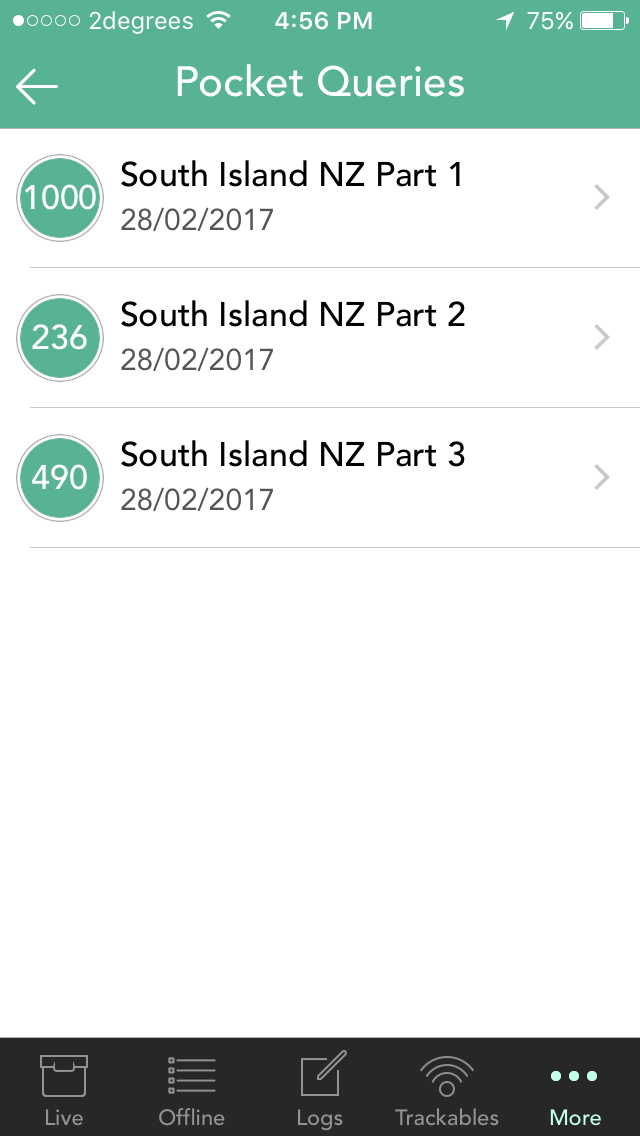
After a Pocket Query is downloaded on the "Pocket Queries" screen, there is no indication left behind that the download has completed and when it was last done. I think it would be a nice addition to Cachly if the individual Queries could be marked in some way (a background or typeface colour change maybe) to indicate that they have already been downloaded. Not sure if it's possible to extend this by having the original colour return if the Pocket Query is refreshed at geocaching.com (which would indicate it needs re-downloading into Cachly). The addition of the date of download (space permitting) would also be a great feature.
 3 points
 -
DNF color in overview screen
ChrisDen and 2 others reacted to Nic Hubbard for a question
Posting this for more discussion. Thoughts? P.S., this is starting to grow on me... 3 points
 -
Adding WP with projection
TheGreenTroll and 2 others reacted to Hko for a question
I just started to use Cachly, used L4C previously, like Cachly better! Thing missing for me is the option to add a WP (while doing a multi f.e.) based on a projection (giving bearing and distance). in L4C you can add a WP where you pick the point from which you want the projection to be calculated ( incl. other already stored WPs or current location), give bearing and distance and it will calculate and create the "WP+1" for you... I hope you understand I am asking for More then happy to explain in more details! thx!3 points -
On the main map page that is displayed when you launch Cachly, click on the map icon displayed at the bottom. It's the icon with 3 stacked squares. In the map window that opens, the top option is Download Offline Maps. Click Download Offline Maps, then Europe and then Belgium or whatever countries you want to have offline. I hope that helps.3 points
-
Send all logs
DavSteph42 and 2 others reacted to Nic Hubbard for a question
Yes, this is a feature that we have been working on. However it isn't a quick and simple thing to add. Here is what has to happen with this feature: Upload pending logs, one at a time to the server. If pending log has a trackable to log, log each trackable one at a time. If pending log has images to upload, upload images one at a time. So there are quite a few working pieces to this feature. That being said, we are still actively working on it.3 points -
Bulk Logging
ElectroQTed and 2 others reacted to ciarmer for a topic
I was out caching today and found five caches. I logged each of these as finds and at the end of the day I had five Pending Geocache Logs (waiting to be posted as field notes). It doesn't look like there is a way to upload all of these field notes at one time rather than one at a time. Is this correct? Are there plans to include a way to upload in bulk? It doesn't take too long to upload five caches individually, but it might get a bit tedious if one has 20 or 30 finds waiting to be uploaded as field notes.3 points -
Streamlining imports
rragan and one other reacted to barefootguru for a topic
Also when creating a new list, Cachly should select it too, to save a needless step.2 points