Team DEMP
-
Posts
619 -
Joined
-
Last visited
-
Days Won
58
Everything posted by Team DEMP
-
The GSAK forum post didn't indicate when it might take effect. Was that included in what you received?
-
Saw this over in the GSAK forum posted by Clyde last night. Not sure of the impact of this change on those using the recently added time zone adjustment option in Cachly. Time zone changes:In order to address long-standing inconsistencies in time zone handling between our website, our apps, and partner applications, we will be implementing a new system for handling time on geocache logs.Currently, geocache logs submitted through the API are converted from UTC to PST. With the upcoming changes, our API will stop the conversion from UTC to PST. The API will pass through the utcDateLogged without conversion and an underlying service will then convert those UTC timestamps to the time zone where the cache is located. Due to the above changes, utcDateLogged timestamps on geocache logs submitted through the API should generally be submitted in UTC without offsets. Additionally, the API will return geocache logs with timestamps converted to the timezone of the cache.Although we understand that not all logs are submitted in the time zone of the cache, we believe that this change will result in many more logs with the date intended by the player.
-
Normally if I don't feel I have a need for an enhancement request, I just don't respond as the requestor or others might have a real need that inhibits use or effectiveness of the experience. Aren't there viable alternative workflows that provide the same or better results for the steps you outlined? Couldn't the selected caches be added to a list and the list accessed and saved offline in Cachly with the full cache details? Is there another reason the minimal Loc file needs to be imported? If Geocaching.com provided a GPX to download, would this functionality still be needed? I know I've seen these requests on their forums.
-
Turn off Search by Cache Name from the top of your last screenshot and try again.
-
Might you possibly have a filter enabled limiting the caches that would display? As an example, if I only allow Earthcaches and then search for 75238, I get the message you posted. If I have all cache types enabled (or whatever your filters are set to), it goes to the zip and displays caches.
-
Here's some snippets from the GSAK FAQ on Facebook related to corrected coordinates. Might just provide some perspective and the sometimes complex options/interactions... 3.4: What is the easiest way to enter corrected coordinates in GSAK? A: There are correct and incorrect ways to enter corrected coordinates in GSAK. I will not point out the incorrect ways. 1. Open the GSAK database with the cache you want to correct. 2. Use one of the following methods to open the Corrected Coordinates window: a. Double click in the Corrected Coordinates Indicator column for desired cache. b. Right click cache and choose the Corrected Coordinates… menu item. c. Highlight cache then choose the Waypoint menu then the Corrected Coordinates... menu. 3. The Corrected Coordinates window will appear with the corrected coordinates currently filled in the Lat/Lon box. If you have not corrected them in the past, the coordinates showing will be the original coordinates entered by the cache owner. 4. In the Lat/Lon box enter the actual corrected coordinates. 5. At the bottom of the window check the Force elevation refresh check box. 6. Click the OK button to save the coordinates. If you correct the coordinates with the steps above, those coordinates will NOT be overwritten by a PQ. If you correct coordinates in GSAK by using the API to Refresh Cache Data and download corrected coordinates that you have entered on geocaching.com, these corrected coordinates WILL be overwritten by a pocket query and the yellow corrected coordinates indicator will be removed. By using the method above, you are ensuring that a pocket query will not ever overwrite your corrected coordinates. If you did enter your corrected coordinates on geocaching.com and then downloaded them using Refresh Cache Data, the corrected method will be shown in the bottom right corner of the Corrected Coordinates window as “Type: api”. Simply clicking the OK button on this window will now change it to “Type: gui” and protect it from being overwritten. If yours says “Type: api” then the coordinates are susceptible to being overwritten. More information 3.5: What are the issues regarding the use of corrected coordinates from geocaching.com? A: There are multiple ways to download caches from gc.com. For this question it is assumed the coordinates on the cache page were changed using the built in capability provided on gc.com for changing coordinates. GPX based downloads treat the changed coordinates as the posted coordinates. The 'Refresh Cache Data..." API does recognize the concept of "corrected coordinates" and transfers both original and corrected. This is the case for: 1) Downloading the GPX file for an individual cache directly using the GPX File button. 2) Creating a PQ that contains caches with manually, online corrected coordinates. a) Downloading the PQ manually Downloading the PQ via the API If you download a new PQ onto of your existing DB containing corrected coordinates, the corrected coordinates will revert back to posted coordinates. Doing a refresh of cache data will fix everything. The short answer is, you can download caches containing corrected coordinates, but you need to run the refresh cache data API to get the corrected coordinates indicator. Alternatively, you can just correct the coordinates in GSAK and they will not be overwritten by any download method. To learn how to refresh cache data see question 5.1.
-
Super quick review, and I have nothing to do with Cachly, is that Terracache outputs GPX 1.1 while Geocaching.com outputs GPX 1.0. This difference causes the structure of the XML GPX files to be very different. I don't know if it's possible to request Terracache GPX output as 1.0 format or if GPSBabel would convert the necessary data effecively. No idea how Cachly is coded for parsing and if it is using a set of routines that know GPX 1.0 and/or 1.1 or if the program is handling via custom XML parsing.
-
Can you attach the GPX for 1 cache - TC9NH - that you imported? The site requires someone to register to get an example to compare what the differences are. Do you use GSAK? Could it handle the transformation by importing into GSAK and exporting a Cachly readable GPX in the interim?
-
Sounds great! If we have a cache with info, updated coords, etc loaded from the unified database and you access a cache in the "live" portion of the app, is it using data from the unified database, data provided in real-time via the API or some combination? Or is the unified "offline" database just used when offline and anything "live" isn't referencing the unified database?
-
Try again, hopefully on Wifi. Also, every few seconds, touch the screen so the phone stays active. Might just be a blip between continents.
-

Cachly 2.1 and map clustering input needed
Team DEMP replied to Nic Hubbard's topic in General Questions
I didn't make my point well. I was suggesting that maybe there are options for large areas being displayed, medium areas being displayed, and smaller closeup areas being displayed and the approach could be different. What might work for a country view covering 200 miles x 200 miles might be different from say 25 miles x 25 miles and different from say 5 miles x 5 miles. Or maybe it's less the display area then # of map points/caches. Of course if there was 1 solution that covered all, no worries. But if not, maybe pick a target to shoot for delivering the optimal experience and let the larger areas have a different experience. -
Cachly 2.1 and map clustering input needed
Team DEMP replied to Nic Hubbard's topic in General Questions
I came back to thread when I was notified Nic replied and I see what I thought was a comment I made earlier this morning not posted to the thread. I guess it's sitting unsubmitted on my ipad at home. My comment had to do with the display window in your video. I'm not sure I'd look at (approx) a 300 mi x 175 mi area like the screen covers and try to find caches. For me, I'd say a 25x25 square mile area is probably the absolute biggest I'd look at on a cachly screen. Maybe others have a *need* to see all of a country like in the video but I definitely don't. I don't see myself needing to see an entire US state at one time. But if there is a need or a viable solution could allow for it, then great. If not, maybe a smaller coverage area should be the target to come up with the best solution? -
Cachly 2.1 and map clustering input needed
Team DEMP replied to Nic Hubbard's topic in General Questions
At the zoom level in the video, if all caches couldn't be loaded I might rather see clustering as it could provide an overview of the entire displayed map vs no idea about the areas in the video. But at the zoom level you were at I'm not sure clustering would be very beneficial either. What about a map display area that's maybe 50 miles by 50 miles with a few thousand caches? The zoom level in the video, if showing all of Ireland is about 300x171 miles and I'm not sure the use case and how practical it is to show an area that large within Cachly populated with all possible caches. -
I seemed to be able to replicate this. I opened a multi cache in live view and put my phone in airplane mode. I went into waypoints and added a new one called stage 3. Cachly seemed to save the waypoint but when I went back out to the live map screen and back into the cache from the map, the waypoint I added was no longer listed. Then I selected an offline list (downloaded PQ) and a multi cache from that list, performed the same steps as above, and when I went out and back into the offline list multi cache, the waypoint WAS there and saved. Still in airplane mode, went back to the live map, selected a different multi cache, performed the above steps saving a new waypoint and it wasn't saved when going out and back into the cache. What I see from the above little test is if you are offline and working in an offline list, Cachly seemed to save the waypoints but not if offline when loaded from the Live map screen.
-
I usually operate with offline OSM maps regardless of signal. I might temp switch to Google satellite view but then back to offline. I can have full 4G LTE and in usually use offline maps. Not sure the above approach would work for me or what the downside is as I normally Send Now while caching and might not launch Cachly after I'm home and back on wifi.
-
Cachly 2.1 and map clustering input needed
Team DEMP replied to Nic Hubbard's topic in General Questions
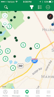
Is clustering something that is determined by the total number of possible map points in the set of possible map points or is it something that is more accurately discussed within any given map display window on the device at a given time? As an example, if a list has 2000 caches, but only 64 might be displayed at the current zoom level of the map and what is displayed, will clustering of those 64 possibly kick in or might they display the 64 individual map points like we see today? I ask because if I use the official geocaching app, the clustering seems to remain even at a zoom level that Cachly has no issue displaying individual caches. So is the constraint the total number of map points (caches) on the map or total number of map points (caches) loaded that might display even if not on the active screen? And if the clustering would still be there, do you have control over when it unclusters as the geocaching.com app seems to still cluster when it shouldn't. Here's about the 2 same screens showing the clustering behavior in the official app vs what we see today in Cachly. Of course I prefer the Cachly screen because I can see much more info.
-
1) click the gear icon at the top of the map where you'd enter the GC code, etc and you'll have filters to adjust what is displayed, including hiding your finds. 2) padlock stops manual map rotation. Automatic map rotation and audio or manual planning and zoning will still work. 3) you can't adjust the info displayed when you click on the icon. Clicking on the pop-up will display the full cache screen within the app which includes the cache owner. 4) not currently a way which is an iOS constraint as far as I know. 5) GC needs to be entered. The following is supposedly undergoing changes for the next release so the behavior might change. I hope the above helps.
-
I use the Cache Note on the cache page screen that shows Description, Hint, etc. The cache note two-way syncs to Geocaching.com with the Personal notes.
-
The traditional icons/color are a bit more obvious/natural then the pure color ones but I use it as a glancing reference. I'm ok with either but if I needed to vote, I'd select the traditional site ones - yellow smile, blue frown, etc.
-
For me it makes sense to be separate because you can do the following based on which are checked... Upload public log immediately Upload field note immediately Upload public log later Upload field note later You need 2 options that are separate to handle those 4 scenarios. At least I think you can do all 4 - I really just use #1 myself.
-
What might help the developer is if you can create a GPX file with an example of each of the above and upload/email it him. He can then look at what GSAK is outputting. Don't send a large file but if you can create a GPX with one cache for each of the above I'm sure it would expedite troubleshooting. Are you using a specific output macro or just exporting the waypoints from your Finds database to GPX?
-
You can send field notes in real time with send now or you can not send now and send later such as when you are home on wifi. But you have to send them at some point. Currently you must send one by one, if you have multiple, but a future release will allow a bulk send. Does that help?
-
Just wondering if the question might be that when he wants to load a new PQ onto his phone, can it be done without internet access available? I don't think so but I might be mistaken on some trick. The cacher could download all the PQs if his phone as space and then switch within the app, but based on how I read the original question, they want to load PQs as they enter areas, and those areas don't have internet access.
-
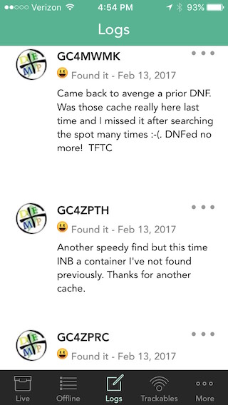
Add cache type to Found/Not Found logs
Team DEMP replied to Team DEMP's question in Feature Requests
Darn that lame API. I should have known! -
I might have missed this as an existing request but I couldn't turn up anything in search. On the main Cachly screen, if you click Logs at the bottom, it brings up your recent logs and shows my icon, the GC code, Found/Not Found/Maint/etc, date and log text but it doesn't show the cache type. Could the cache type (Traditional, Multi, Mystery, Virtual, etc) be displayed on this screen as well?