brudderman
-
Posts
56 -
Joined
-
Last visited
-
Days Won
6
Everything posted by brudderman
-
This has been a standard feature of Google Maps for quite some time and did work in Geosphere when the Geosphere still supported Google Maps. I just checked my old iOS 9 Geosphere to make sure. I normally navigate to caches from within Cachly using the three dots to select routing in Google Maps, and it works that way also. Would be nice if Apple did make it available elsewhere.
-
Yes, I can see how the extra information downloads on live caches could be troublesome, but it would be nice at some point if there’s a reasonable workaround.
-
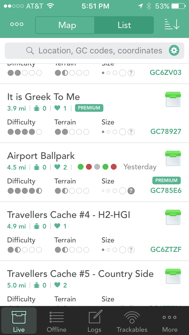
I suspected that space could be an issue, but there appears to be sufficient "white space" immediately to the right of the favorites (line 2 of the current 4) for five log icons (either colored dots or perhaps the new smilies) and maybe even the date (in a compact format such as mm/dd/yyyy if necessary ) without having to add an extra line. This would require the relocation of the "Premium" identifier, perhaps to line 3. A rough example (Airport Ballpark) is attached to show how it might be done. The new filters sound great and would certainly be a welcome addition! Hope Nic puts them "on the list"!
-
When I view a cache in list view there is basic summary info (distance, trackables, favorites, difficulty, terrain and size) that's instantly visible and extremely helpful in getting an overview of the cache. This same info appears in the box that pops up when a cache icon is tapped in map view. Then if I "click into" the cache from either view, there are further details such as recent log icons and date last found. I may have missed previous discussions of this, but is there a way to enable the display of the recent log icons and date last found along with the other basic summary info without having to "click in" for further details? Given limited time in an area, it would be mighty handy to be able to quickly scroll down a list to spot caches with successive DNFs (to avoid those if desired) without having to click on each individual cache to see its history--and then try to remember the ones to bypass. Thanks!
-

Getting good coordinates for cache placement
brudderman replied to brudderman's topic in General Questions
@ChrisDen Thanks for suggesting this! I often look at where a cache I'm hunting appears on Google Maps satellite view to see how my location compares. This is helpful as long as I have and internet connection to download the satellite map images since they apparently can't be saved offline as are the regular maps. I've never used Google Earth in this fashion but will begin to experiment with it and try your procedure. Thanks again. -
I'm going to start placing a few caches and will, of course, need accurate coordinates for that. I know that I can tap on Cachly's current location indicator and get a popup with the coordinates (and the accuracy) and an option to copy them. But will this single sample be good enough placement? If so, then I'm set with what I already have in Cachly (my "go to" app which I do love!). In some areas coordinates bounce around quite a bit, so it seems that an average over several minutes would be better in such cases. Not having a dedicated GPSr, how would I go about getting coordinates that are good enough to post for placement with my iPhone 6s? Perhaps another app for this occasional single purpose? I apologize for my ignorance here but would sure appreciate suggestions and pointers from those with experience in this. Thanks!
-
Though certainly not a "must have" caching need, it would be mighty handy to be able to import waypoints into an offline list. For example: I have a GPX file of cemeteries in my state, and many times I'd like to see which ones are near the caches I'll be visiting. Similarly, I also have a GPX file of waterfalls and like to see if any of them are in the vicinity. Maybe feature to consider "one day." James
-
Thanks, rragan! I now see what I was doing wrong. After the first capture of a group of caches along a route, I should have been saving to an offline list right then with subsequent captures being saved into that list. I was trying to do all of the captures and then save to a single list at the end. Thanks to you and MrGigabyte for alerting and helping me with this option!
-
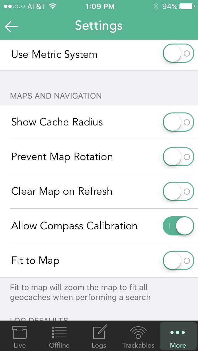
I do use offline lists and GPX export but have never tried to accumulate a set of caches along a route, which would be very handy. So help me understand what I may be doing wrong since I'm having trouble duplicating your procedure and getting it to work. Here's what I'm doing: I see 5 caches on my way out of town and zoom the map to include just those on the screen and hit the circular refresh button. Then I pan the map a little further up the highway and see 7 more out in the country that I also want. Again I adjust the zoom to include only those and refresh again. Then a little further there are 10 that I want to add, so zoom and refresh once more. But when I go to save the offline list and choose Visible, I get only the last 10. And if I choose All, there are 159. What I want are only the 22 in the three groups, and that sounds like what you are accomplishing. So I must be missing or misunderstanding something simple. My settings are shown below, and any pointers would be appreciated!

-
I do put watches on DNF's of particular interest, but not all of them, and that works well. What I'd like to have is a way to easily highlight all DNF's that have been found by someone else just to make them stand out on the map if I happen to be in a particular area. I could certainly put a watch on every DNF and then manually highlight the ones where someone reports a find. But the nerd in me is always dreaming though....
-
Just a couple of thoughts: 1. This past weekend I had an offline list of several hundred caches around a particular city, but I was only interested in those in the southeasterly direction. So a directional filter (N, NE, E, etc.) would sure be handy sometimes to eliminate some of the clutter. 2. Though probably way too complex to practically consider, I like to look again at caches that I have logged as DNF but have been found since that time and then decide if a return trip is called for. Right now I do that in several steps. First I create a GPX file of all my DNF's in iCaching and export that. Then I import that file into FileMaker Pro and run a script to mark those caches with a found date more recent than my DNF date and export a file of those. Then I import that file to a group/list in Geosphere/Cachly. Pretty tedious, but it works and lets me highlight those I'd like to revisit. There's surely a more efficient way to do this, and I'd sure be open to suggestions since I'm probably missing something! Thanks for a great app and all the hard work!!! James /\__/\_____ (=-.-=),,__,,_)~~~~ Ol' Brudderman (R.I.P.)
-
Having more that one highlight color choice would sure be nice also!
-
Great! Hopefully they won't change the syntax again and break it! Will be looking for the update! James
-
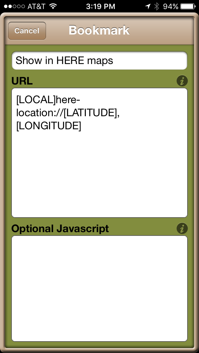
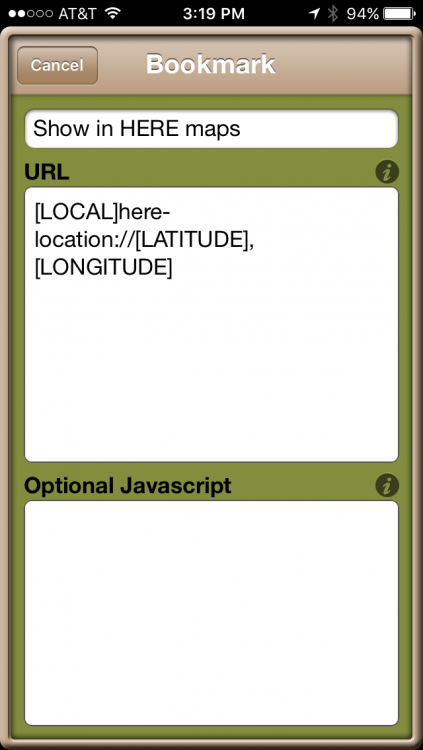
Yes, I'm using a custom bookmark in Geosphere that works properly. In August 2016 I contacted HERE support because the syntax which had once worked had been "broken" with an update to HERE. Here's what they said: "We are no longer supporting this format of the deep links. The new format is the following: here-location://[LATITUDE],[LONGITUDE]" I'm attaching my working Geosphere bookmark even though it doesn't appear that I need the [LOCAL] token. Does this give you what you need to know? thanks! James
-
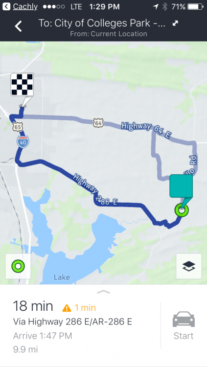
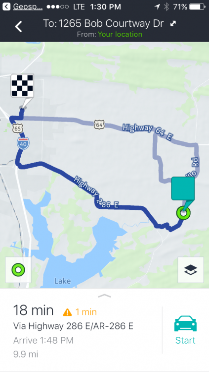
When driving to a cache I'll often use HERE Maps for turn-by-turn voice directions to get me in the near vicinity. I've been having trouble getting this to work in Cachly and hope someone can help me figure out what I may be doing wrong. Here's my procedure: 1. Tap the icon for the desired cache 2. Tap the pop-up info box for the cache 3. Click Navigate to Cache at the top of the cache info page, which switches to the Maps page 4. Click the three dots in the upper right corner of the Maps page to bring up Routing Options 5. Select the HERE Maps routing option HERE Maps does open and properly shows potential routes from my location to the cache. As shown in the 1st screenshot of a routing activated from Cachly, however, the Start button is greyed out and can't be selected to activate real-time routing. I can see my position move along the route, but that's about it. No change in distance, arrival time, etc., as HERE Maps isn't actually routing me as I drive. Trying the routing in Geosphere (2nd screenshot) produces the same page in HERE Maps as Cachly does--but the Start button is green and can be clicked to start a route with turn-by-turn voice directions. I don't see any options in HERE Maps to produce different behavior so I wonder whether I'm missing some critical step or setting. I'm using an iPhone 6s with iOS 10.2.1. Any suggestions on getting HERE Maps to start routing? Thanks! James
-
Yes, you are right! I was originally referring indeed to bringing the maps INTO Cachly--and that's where the sandboxing comes in. I just tried Google map navigation with airplane mode, and it works great! Being new to Cachly, I had the concepts or map layers and navigating by map mixed up in my mind. Now I understand. Good news on expanding the URL scheme! Will be on the lookout. Thanks again!
-
Thanks, Nic! The one I use is Topo Maps by Phil Endecott (https://goo.gl/NUo1pZ). Have used it for years. It may not be possible to automatically add a dropped pin to Gaia, but I made a request to them several years ago, and it seems like it was acted on. But that could be only for the paid subscription service. I'll do a little research. Now concerning the offline Google maps. I'm a user of FileMaker Pro (and the iOS version, Filemaker Go) and have a database of registered voters on my iPhone. This includes voter addresses, and I'm able to go to an address in an offline Google map in their maps app. Here's the basic procedure: 1. Download the desired offline map area in Google Maps on the phone. 2. In Filemaker construct a URL with this Google map syntax: http://local.google.com/maps?q=FullStreetAddress, City,zip 3. Turn on airplane mode to simulate no cell service 4. "Execute" the above URL with a FileMaker script step. If the address is in the previously downloaded offline area, a pin will be dropped in the Google Maps app at that point. If the address is not in the offline area, then nothing happens. No map, no pin. So it might be possible to do something similar in Cachly to access the Google Maps offline maps. One other thing that perhaps might deserve its own thread. The iOS Workflow app (https://goo.gl/FrD0Pz) permits some incredibly complex automations in iOS and might be a way for Cachly to be customized by users beyond it's native built-in capabilities. I'd expect that certain data in Cachly (coordinates, etc.) would need to be exposed so that Workflow could be programmed to set variables, etc., that could then be passed to other apps and processed. Just a thought in case you're not familiar with Workflow. there’s a subreddit group dedicated to Workflow where many complex automations are discussed. Just another wild idea for your "spare time"! Thanks again for all the work you put into Cachly!
-
Thanks for explaining, Nic! The offline Open Street Maps are sufficient in most cases, and the download for my entire state is very small! And for turn-by-turn navigation, the offline HERE Maps and Maps.me generally fulfill my needs in getting near a cache. I have downloaded areas of interest in Gaia GPS, and activating navigation from Cachly in airplane mode (to simulate no cell service) does switch over to Gaia properly. Sometimes the Gaia maps are very fuzzy after the switch, but I'll experiment more. Having Topomaps as a option here would also be quite nice since I have downloaded many megabytes of tiles for offline use. It would sure be nice to have a pin automatically dropped at the cache coordinates in both Gaia and Topomaps when the switch is made, but that may not be possible. Too bad about the sandboxing of offline Google maps. Would be nice to have them available as well. Thanks again for a great app and for the continual improvements! Lots to learn here! James
-
I have downloaded my state Open Street map, and that appears to work quite well if that sort of map is all that I need. There are times, however, when I need other map types in areas where there is no cell phone coverage, but I don't see whether they can be deployed as map layers in Cachly. 1. Specifically, I have purchased and occasionally like to use Topomaps (https://goo.gl/QHm4pQ) and Gaia GPS (https://goo.gl/MvkxWI). Is it possible to navigate to a cache in Cachly using such maps? If Cachly would recognize them as additional map layers along with the standard ones, the would be great. That feature may be there, and I'm just missing it. 2. Using the Google Maps app, it's possible to download offline map areas. Is it possible to use these offline maps with Cachly? Thanks!
-
Found and not found yet Toggle in maps
brudderman replied to Stearman5's question in Feature Requests
I believe you have previously given a target date for the 2.1 version but haven't been able to find that post. Is it after the first of the year? Thanks! -
Found and not found yet Toggle in maps
brudderman replied to Stearman5's question in Feature Requests
Thanks! At least I didn't overlook something obvious. I'll be looking for the update! -
Found and not found yet Toggle in maps
brudderman replied to Stearman5's question in Feature Requests
this does work well for "live" caches, but are the same options available for offline lists and maps? I'd like to hide my found caches when viewing a pocket query offline but am just now learning Cachly (v 2.0) and could easily be missing the feature to do this. Thanks!