rragan
-
Posts
1003 -
Joined
-
Last visited
-
Days Won
75
Everything posted by rragan
-
This would be cool but I doubt it is as important as many other 2.1 candidates.
-
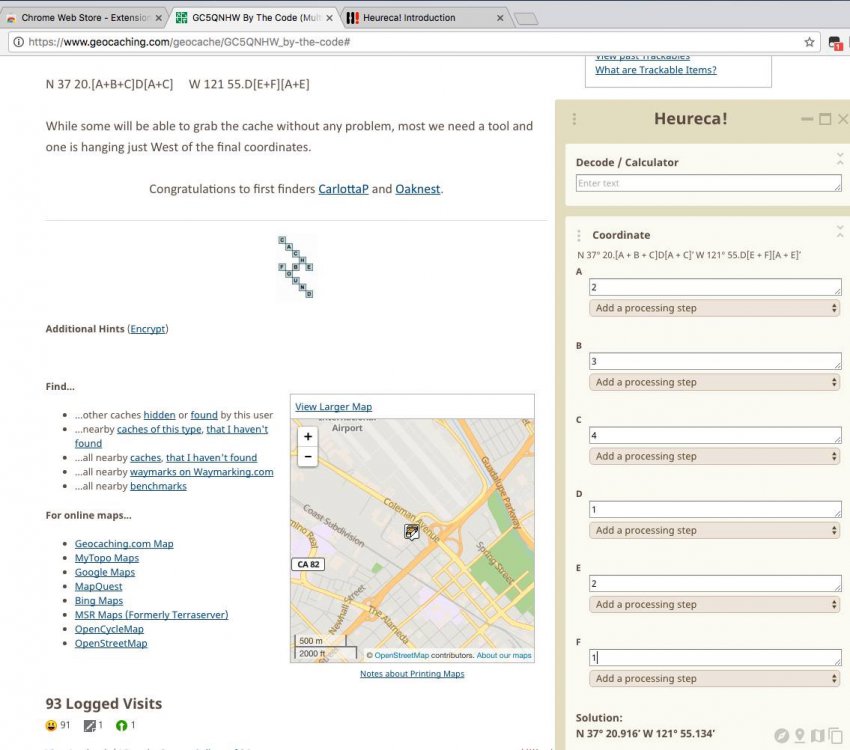
I'm pretty sure this is on your feature list but a new web-only Chrome plugin was announced today. It parses the description looking for formulas and then as you gather values doing the multi, it computes the formulas. See http://heureca.net. Here is a sample where I used it on a multi. It is cool but of low value to me in the field unless I'm schlepping a laptop around. Cachly would be so cool if it could do this.
-
Red seems like don't go and black is dead (eg archived). Maybe draw from Road signage - No Entry of Red Circle with red slash, See Unicode icon. Then same icon but with black colors for archived.
-
Cachly 2.1 and map clustering input needed
rragan replied to Nic Hubbard's topic in General Questions
Interesting idea. It feels a bit modal. What if the caches I'm interested in span two different display chunks? When do I drop out of this mode to swing into action on some of the caches? Don't you need to keep state when I still down to a cache and come back? i think I prefer clustering with an option to disable and a fairly high threshold that would generally be safe. 1000 threshold ought to show most geoart. -
I like it. What would archived be? Black?
-
Cachly 2.1 and map clustering input needed
rragan replied to Nic Hubbard's topic in General Questions
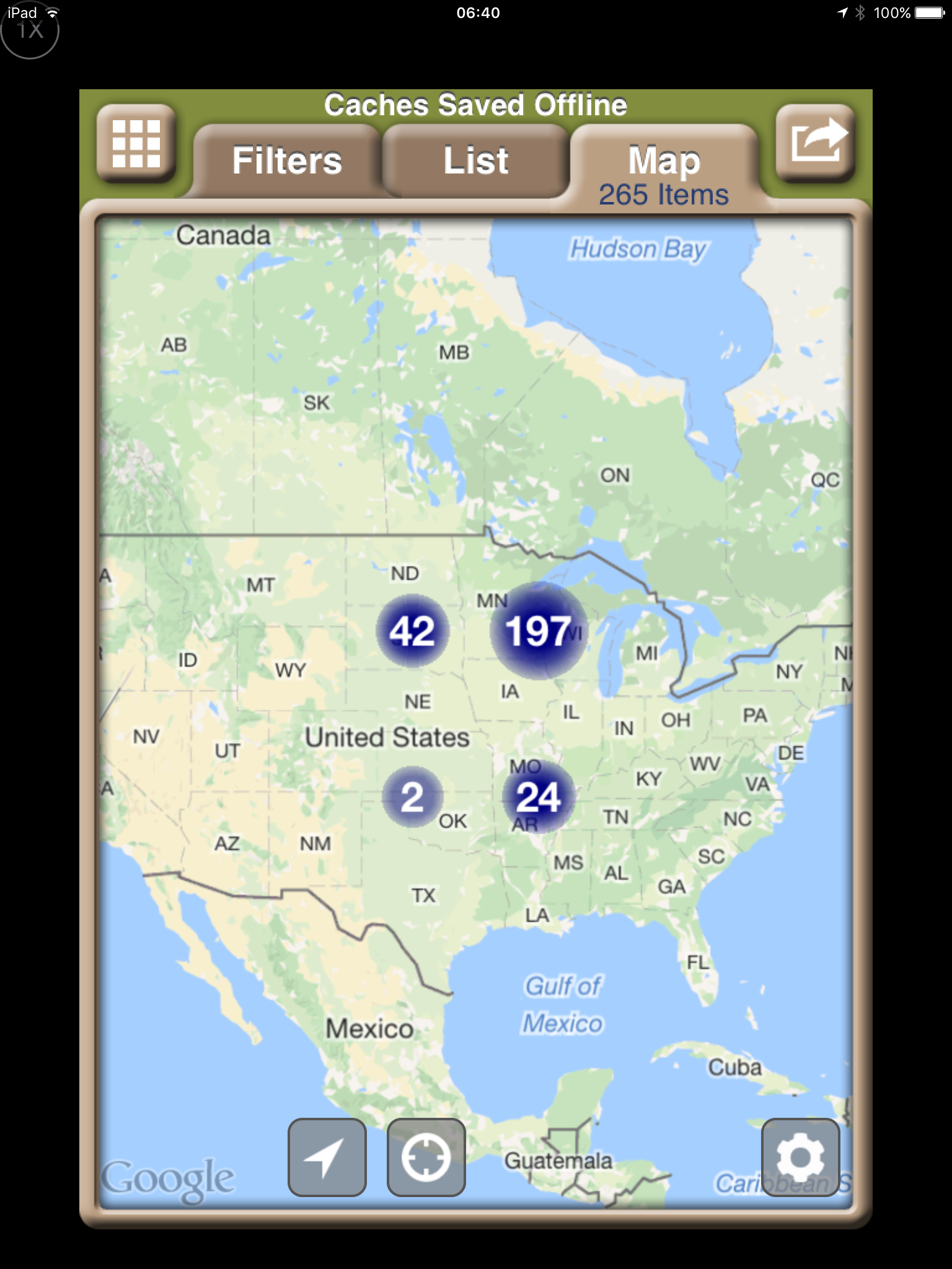
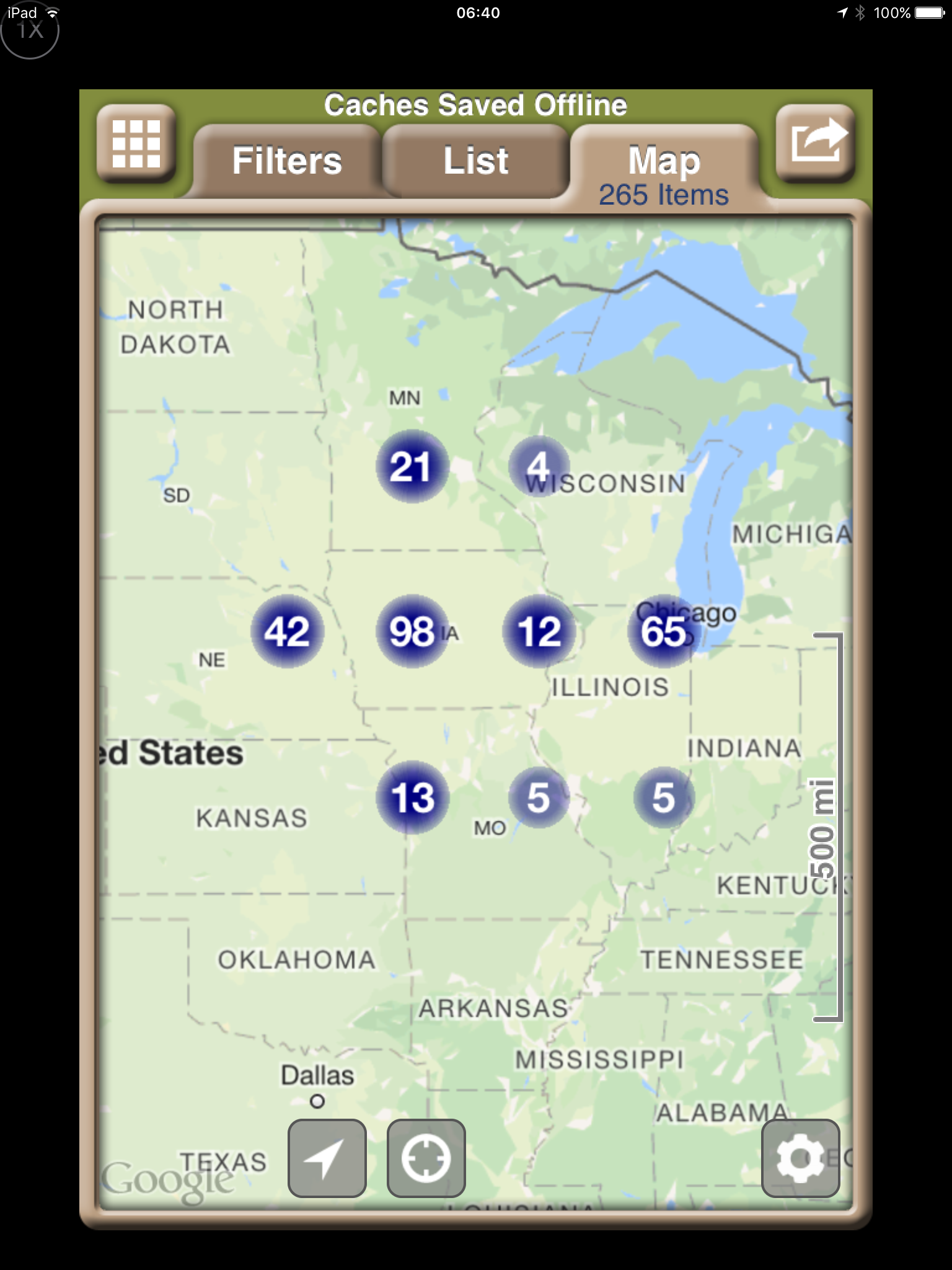
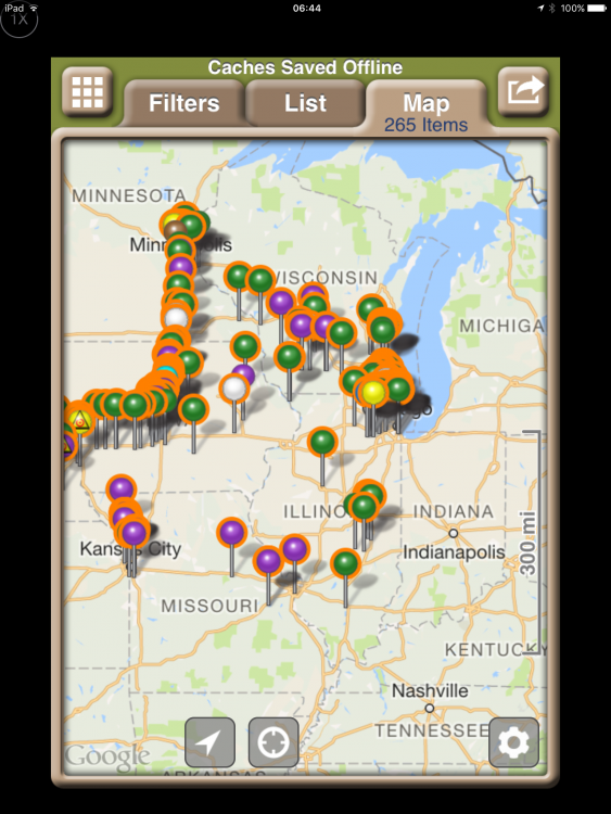
I played with clustering in Geosphere to get a sense of what the algorithm might be. It looks like at 250 or more pins in view triggers clustering and it is an all or nothing thing. Here are 3 screen caps of an upcoming trip with a total of 265 pins as I zoom in. When the visible count drops below 250, nothing is clustered. The small clusters of 1 and 2 are annoying.

-
White text on green background does not work
rragan replied to assankassa's question in Feature Requests
Coordinates line is especially hard to read with grey text on a grey background. In general, higher contrast is better for an app being used outdoors in sunlight. -
Can you make it more fault tolerant so it can deal with a missing comma. Also will it accept d.mmmmm ( decimal degrees) and degrees/ minutes/seconds? This hearkens back to a general coordinate parser.
-
Re opening in app My behavior opens in Safari with an option to open in Geocaching app. I vaguely recall that if it opens in their app you can tap geocaching.com in the upper right to open in web page. I think the choice is sticky so you may be able to open directly to Safari from emails. This can be handy because if you then tap the GPX file button, you will be offered to open in an app that handles GPX files -- likely to be Cachly for you. Then you can import the single cache to an offline list. Having a list named NewCaches would let you easily grab new publications for later finding.
-
Just be careful if you go to edit the notes on a web page. For some reason, the web page limits the total number of characters and truncates any excess when saving. Apps can store much longer notes without any trouble via the API. An extra long note can be viewed on the web but don't try to edit it there or you will lose data.
-
Move the sort onto the right of the cache count line. I know this means it can scroll off but this has rarely been an issue with Geosphere which had it there. Adding it to ... would be ok I think but need to see a mock.
-
Having to guess/remember the meaning of dot color is not great to my mind. I screen captured Looking4Cache app and blended their use of icons with a Cachly screen cap. The result shows that the more mnemonic icon circles they use ought to take no more real estate than is currently used. A blue frownie, yellow smiley, etc then are like the map view.
-
Yes. Export can be done from Map view but not List View because the list ordering control usurps the space.
-
The red line from current location to target is already there.
-
I don't have a suggested fix but it is odd that I can only export a list from Map view but not List view. Took me a bit of poking around to figure out how to do it.
-
Not sure if the resolution would permit but a small blue dot with a frown and yellow with a smile would remove the ambiguity.
-
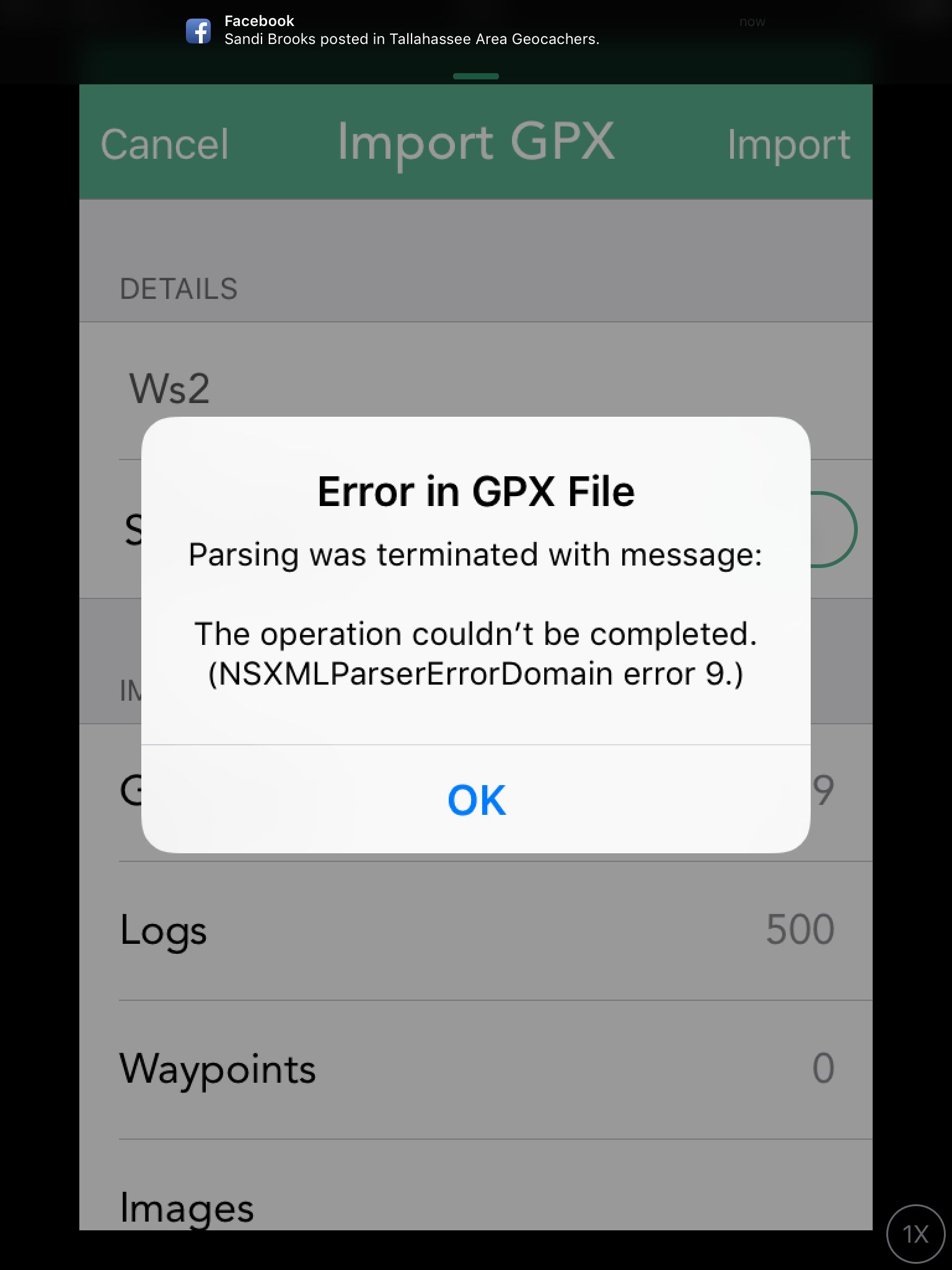
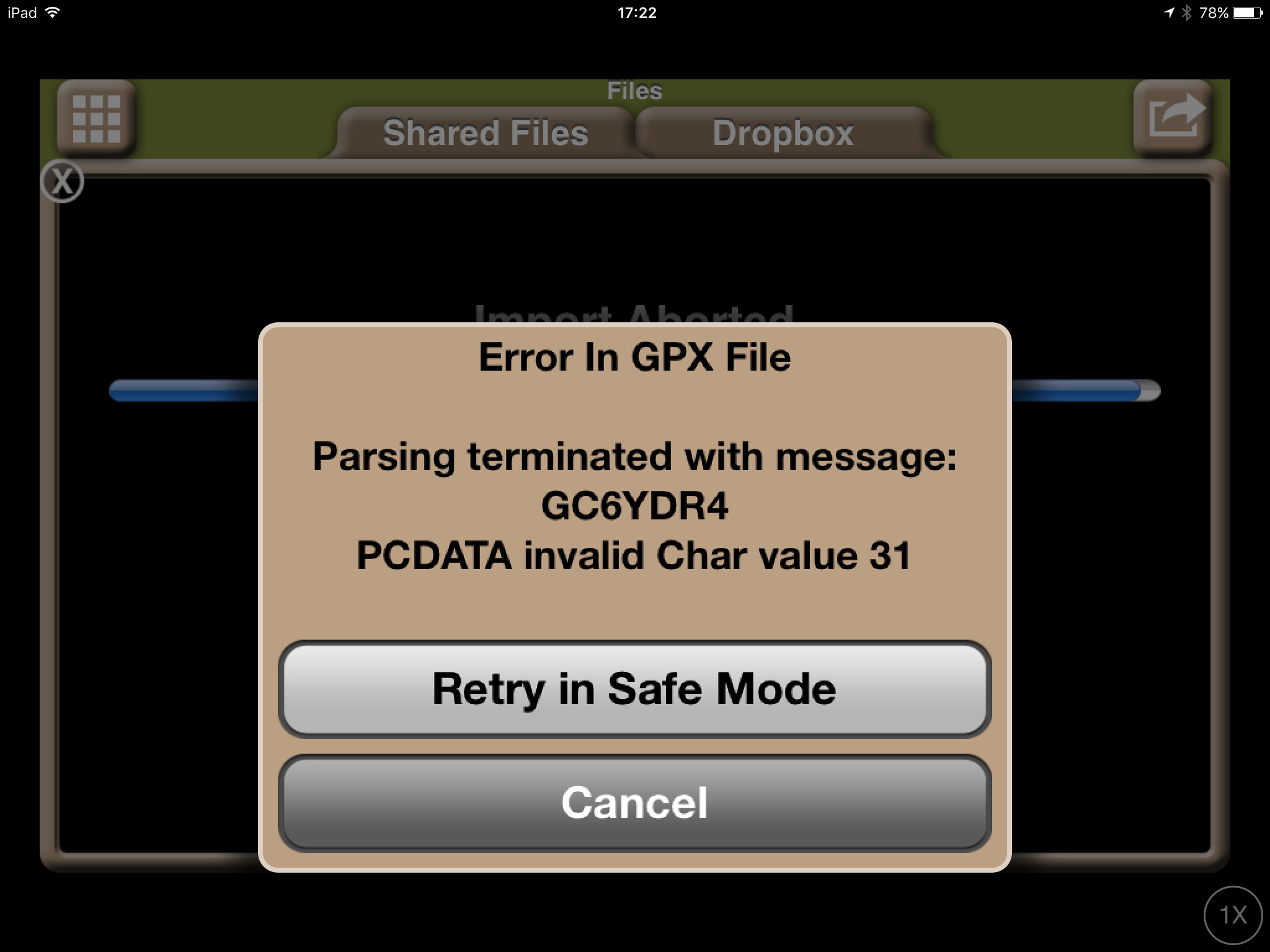
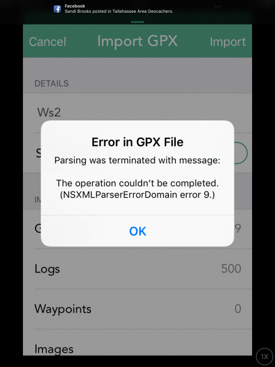
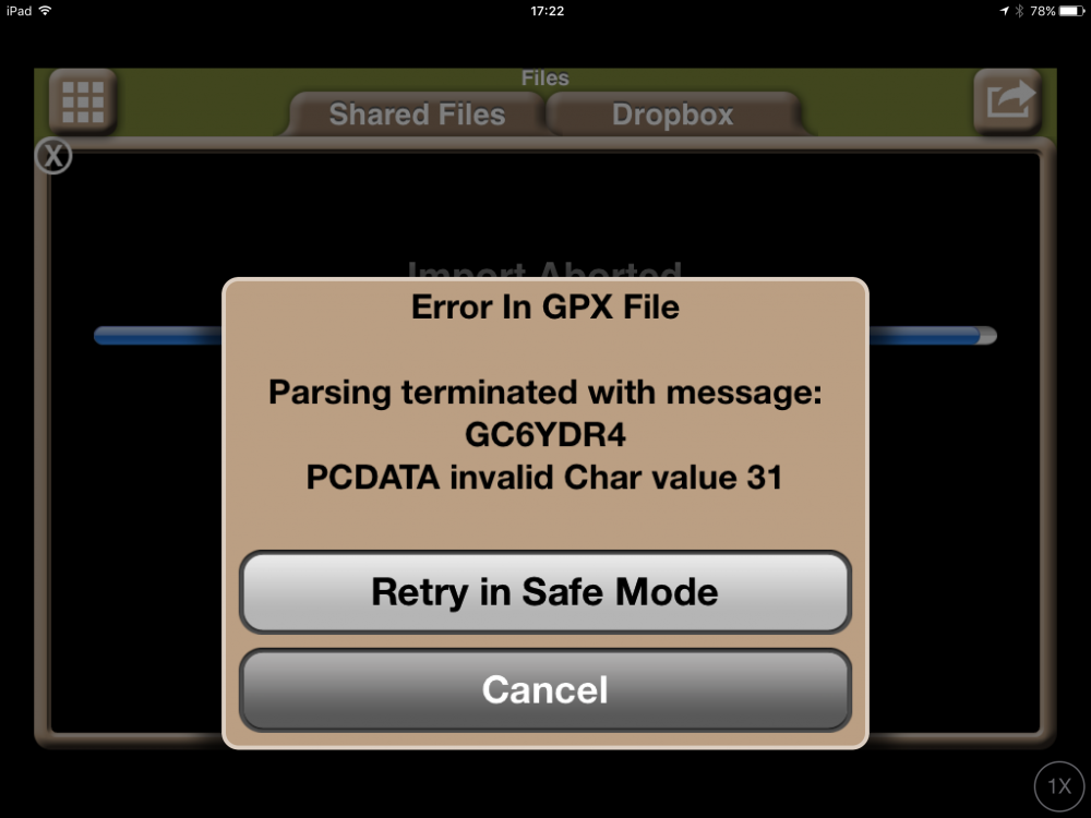
i did a cache title search with Cachly and imported it into Geosphere. The import failed with the error shown in attachment. I then recreated the list of caches in Geosphere and imported them into Cachly to see how the error is handled. It fails in the same way but there is no information to let me know the cache with the bad text so I can avoid it. Showing the problem entry helps a lot. Better yet would be to report the offending entry and continue the import with the next cache. The way you process the XML may prevent doing this. Curiously, I can load the cache in both apps and export ok. Only the import fails.
-
I use this capability in Geosphere. It is particularly useful when I have filtered down the cache list to the interesting ones and want to highlight just those. As we get better filtering for lists, this becomes valuable there too.
-
I have recollections of a discussion about an option to do full download on Live cache results. I know it cuts into the daily limit but the delay to see the description when out and about is annoying and sometimes problematic if I'm out of cell range. Did this option not make it?
-
If you get the zip/GPX on the phone and in a cooperative app, you can selectively import the file while offline. Easiest is to have it in email and downloaded. I just used an app called ZipTool to download the file and then was able to load it into Cachly in airplane mode.
-
Sure. Geosphere only shows ones done on the device although it does support export/import of logs so you could merge them on to some other devices. Once in a while this is annoying but I log most caches in the field on a single smartphone. Others style may differ and that would make this less desirable.
-
Thanks. That works fine. I'll make s separate feature request one of these days for standalone user defined waypoints but not now. Low priority for me.
-
How about burning some memory and keep the last n logs with more cache info. That is what Geosphere does. You can also see the cache entry in full which is handy
-
I often manually want to drop a pin and then get driving navigation to that spot. This deals well with a cache placed on a frontage road next to a freeway. Typically the navigation application wants to put me on the freeway and tell me I have arrived when I get next to the cache I can't reach from there. By dropping a pin a small distance away from the freeway, the navigation application typically avoids this problem. Padding an option to dropped pin to Navigate there would help greatly. Otherwise I have to hack around by taking the coordinates of the pin and making them a waypoint for the cache in question and then later removing the waypoint. Doable but a lot of messing around for something that could be a lot simpler. I would see this is the first step towards user-defined way points. These have a variety of uses when traveling to points of interest or hotels or any place you might want to navigate to and write notes to yourself about what is there.
-
Sort of but not all search options. Minimally exclude my finds/hides as day-to-day I don't want to see these by default. I know they are there and they block seeing more results of interest. If I could solve a few more puzzles, there would be nothing but my finds in the initial view around home. Not useful when searching.