wwbd
-
Posts
24 -
Joined
-
Last visited
-
Days Won
1
wwbd's Achievements
")
Newbie (1/14)
9
Reputation
-
 Nic Hubbard reacted to a post in a topic:
Asterisks being stripped out of log display in 5.0.2
Nic Hubbard reacted to a post in a topic:
Asterisks being stripped out of log display in 5.0.2
-
 wwbd reacted to a post in a topic:
Asterisks being stripped out of log display in 5.0.2
wwbd reacted to a post in a topic:
Asterisks being stripped out of log display in 5.0.2
-
Like I said it’s minor and it still works for its intended purpose. Cachly just doesn’t display the asterisk but it uploads properly. I just thought I’d report it in case there was something else going on. Thanks for the explanation and quick reply!
-
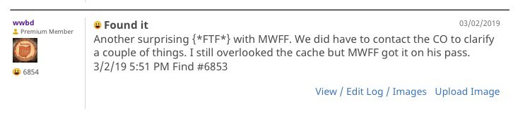
I've noticed a small bug in 5.0.2. I use Project-GC to log my First To Finds. So for it to recognize that, I type {*FTF*} in my log. When I go back and look at my logs in Cachly I only see {FTF} without the asterisks. If I look at the logs from a browser or the official app the asterisks are there. So it seems to be a display issue in Cachly where the * is being stripped out.
-
Attila_G reacted to a post in a topic:
Google Maps in 4.3?
-
wwbd reacted to a post in a topic:
Google Maps in 4.3?
-
I used the hybrid Google Maps the most outside of offline maps. You could zoom in closer with those than Apples hybrid. I’ll live but I’m glad they’ll be back in v5. Can the ability to hide maps I’ll never use be added like Ordinance Survey and Thunderforest? It would be nice to get a better terrain map in there too.
-
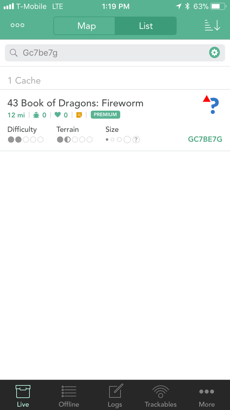
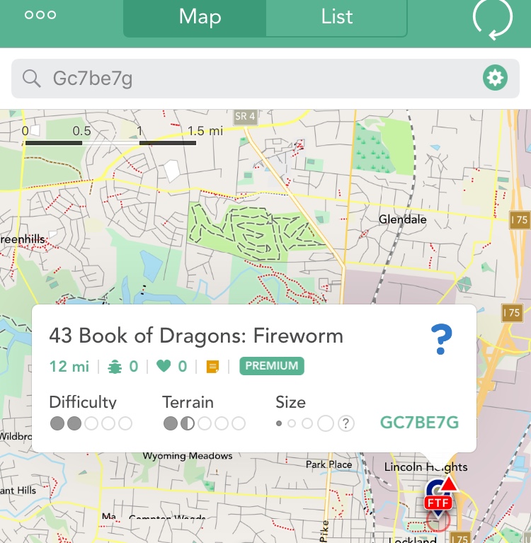
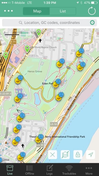
I love the FTF icon feature. I did notice what might be a bug. In this case the cache was enabled, CO disabled it to fix something and then re-enabled it all before it was found. The List view does not show the FTF label on the icon but the Map view does. Current example is cache GC7BE7G which is still currently unfound. Another example is GC7BNAM. Update: It appears this might have more do do with having corrected coordinates on a Mystery cache. Both of my examples above have corrected coordinates. When I remove them, the FTF comes back on the List view.
-
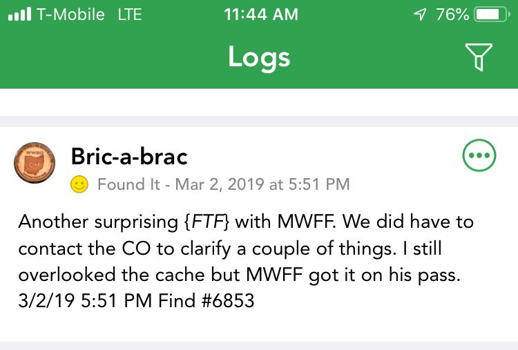
As a Geosphere refugee I was just talking about this the other day. I've been using Cachly since January and miss this feature. Can the daily count somehow be added to the Logs section as in the above screenshot? So for March 25 2017 above that's the (13/0/0), which is Finds/DNFs/Notes... Or anywhere? Maybe it's there somewhere in Cachly but I can't find it? I've found it useful when reconciling cache numbers with another cacher that day because sometimes in all the fun one of us ends up logging a cache incorrectly or not at all.
-
Is the ability to average a waypoint still on the todo list? Just wondering...
-
ppporch reacted to a question:
multiple choices for Default Log text
-
No. I'll try next time I'm out. One more bit I just remembered that has to be relevant... I had just logged a find on a cache that I previously DNFd a while ago. Then I switched maps. So that may be the key.
-
I think all I did was switch from Google Hybrid maps back to offline maps and the map showed all my finds that day as DNFs and Finds. I clicked the circle arrow thing to refresh and they stayed that way. I had to clear the map and search again and they came back correctly.
-
Nic Hubbard reacted to a post in a topic:
Log Text keywords
-
I like the Log Text feature but it would be nice to have multiple selections to choose from when logging finds. Also, when logging a DNF or anything other than "Found It" the default Log Text should be disabled, or if implemented, give you the option to choose from one of the other multiple selections. People are probably not saying the same things when DNFing a cache vs when Finding it. I also like to put my find count in the Log Text and obviously I don't need that when I'm not finding it and it is in fact adding a find to the counter because I guess Cachly must just see all logs as an addition to the counter. Thanks for the hard work you put into this. I've been using it exclusively since 2.0 came out.
- 1 reply
-
- 1
-
-
I was just browsing and saw this topic. I had this happen to me a few times over the weekend and thought I was just fat fingering the icons
-
wwbd reacted to a post in a topic:
Logging Trackables when Offline
-
wwbd reacted to a post in a topic:
Map tile caching problem
-
wwbd reacted to a post in a topic:
Map tile caching problem
-
wwbd reacted to a post in a topic:
Map tile caching problem
-
Thanks. It sounds like I just need to change my routine when venturing away from home. Do a search, save offline and make sure I have that states maps downloaded. I live in Cincinnati. That's in Ohio but at the junction of Kentucky and Indiana so it's not unusual for me to be in 3 states on one geocaching run.
-
I should have searched the forums first. It looks like I have to go into map layers while in Offline mode and select the state I want and then I can see them in Open Street? Is that right? That's actually better than having to manually load the map data by scrolling around.
-
I like the new version BTW...however i did run into a problem. I used it this weekend and I was in some areas where I had no cell data signal whatsoever. I was familiar with the location and anticipated that problem. When I used the product Geosphere, I would go ahead and scroll around the area on the map, zoom in and out, etc to cache the map tile data in case I would lose my data signal. That way I wouldn't be stuck without a map. I did the same thing with Cachly but when I lost my signal, the map just turned to a blank grid no matter what zoom level I was at. I was using the Live map vs Offline. Luckily I was with someone who had a signal so we used his map otherwise I would have been dead in the water. I thought the caching of map data was a function of iOS, but that doesn't appear to be the case. Is there some setting I need to change? What's the story here?
-
Nic Hubbard reacted to a post in a topic:
What a great product!
-
wwbd reacted to an answer to a question:
multiple choices for Default Log text
-
I just wanted to say what a great product Cachly is! Message forums, reviews, and social media can sometimes turn into a big complaint desk. I mean how many times have you contacted a company to tell them what a great experience you had? I work in IT and hardly anyone, ok no one, calls up to tell me how great the network is today or whatever. I've posted a few suggestions here and reported a couple of possible bugs since I started using Cachly but my experience overall has been fantastic and the developer responds quickly. Keep up the good work, looking forward to v2.0!