

Nic Hubbard
-
Posts
3973 -
Joined
-
Last visited
-
Days Won
409
Posts posted by Nic Hubbard
-
-
That sounds like a great feature. Will get this added to our Feature List.
-
This is possible in Cachly. You will need to tap the Log this Cache button and when presented with the log screen, toggle the top option so that you can save the log instead of logging it.
If logging/saving a Found It log you will see a checkmark on that cache, if it is a DNF you will see a blue frown face.
-
12 hours ago, rragan said:
Importing a zipped GPX file seems create two import Windows. I use one and then cancel the other but does not seem right
I have seen this happen periodically, but it should not always be happing (I get it maybe 1 in 100 times). So far I have never found the source of the issue, but I do have it on my bug list.
-
27 minutes ago, Bolling said:
Interesting. I didn't even realize that you could Airdrop from Geosphere. Anyway, I just tried and had the same issue you described.
Airdrop is a Bluetooth technology. I think that @rragan means he is using the share option, which just shares the GPX between apps.
-
This is something that I have on my list and know it is a small limitation. Hoping to get it added in 2.1.
-
Yes, as @Bolling suspected, this information is not in the API. I had really wanted to add this about 3 months ago, but I made sure to look really close in the data that is returned and sadly Groundspeak doesn't provide this.

-
Some areas don't have the higher resolution Flyover maps, so if you are checking in a rural area you might not see them.
-
-
Description, Hint, Logs and Attributes are not something that is part of Lite data from the geocaching.com API. So if you had previously had that info, from an PQ, GPX or saving from the Live tab that info would get overwritten if you are Updating Caches with lite info.
In the future we will work to better merge the info so Full info wouldn't get overwritten.
-
2 hours ago, rragan said:
Yes and link the screenshot to the cache via the feature being discussed.
This shouldn't be a problem, since it is for personal use.
-
1 minute ago, JohnCNA said:
I have V2.0.3 and can't find an option to refresh an offline database. I can only find an option to refresh a cache and it's logs one at a time. Has this been added yet or is it still in the future?
When viewing an Offline List, tap the ... button and you will see an "Update Caches" option.
-
2 minutes ago, rragan said:
One of my reasons for offline storage would be to capture the most zoomed in sat view tile before going offline. Do you figure that violates Google term of service?
Do you mean you would just take a screenshot of it?
-
2 hours ago, rragan said:
I like the sharing aspect but would they be on any device that had synced with the cloud? I'm concerned about viewing the image in offline mode.
Yes, if we implemented the iCloud feature that I mentioned, then yes. Or another alternative would be to just store the images on the device.
-
2 hours ago, TheGreenTroll said:
I haven't explained the question very well.
When you mark a cache as found in Cachly it displays a white tick that still can be seen on the map and changes to a smiley once a log has been sent.
I don't mean cache's that have been found previously and logged as these are filtered out already via the live search settings or when generating a PQ on geocaching.com.
Hopefully this explains things better?
This advanced filtering isn't something that is in the current version, but we are working on adding it in 2.1. You will be able to filter by a large number of parameters in Offline Lists.
-
1 minute ago, Team DEMP said:
So to be total offline, you'd use offline downloaded maps and PQs, but they both work well even when online.
Or you can load up caches in the Live tab, then tap the ... and choose to save those to an Offline List. Or, you could import a GPX of caches. Many ways to have caches offline.
-
Just now, ajlepel said:
Thank you Nic. Is all of this documented somewhere? Am I the only one who does not know any of this?
Thanks again. I'm loving this app you've created. I'll be following the forum and your website from hereon.
These are documented in the Help section of Cachly. Many of the features like this are built to be very intuitive so that we don't have to have vast tutorials. However we are more than happy to answer any questions when confusion arises!
-
3 minutes ago, ajlepel said:
Is it my understanding that Offline Maps will enable me to find the geocaches from my Pocket Query? Is there a way my Pocket Query will be mapped out on my iPhone when I'm out of signal? How do I get the geocaches from my Pocket Query to show up on Offline Maps? If the geocaches do appear on my Offline Maps, will the compass on Cachly direct me to the geocache? I hope I'm making myself a little better understood.
Yes, this is all possible. What you need to make sure to do is go to the More tab in Cachly, then to Pocket Queries and download your PQ to an offline list. This is the first step. Second, download the offline map that you are needing and you are good to go.
When you have no service make sure to turn on the offline map that you need, and then view your downloaded PQ in the Offline tab. Then you can navigate to any of the caches, view info about them, etc all while offline. The compass and GPS both work while offline.
-
The Map Options (stacked icon) can be accessed from any map screen, so you can download or change maps on any of these screens.
Please let us know if you have any questions about this!
-
1 hour ago, rragan said:
Navigate to cache. Drop pin. Create as Waypoint. My confusion is due to the pin and the waypoint blue circle both being present. I clicked the pin and did Remove and the waypoint circle remained. The wording "Create as waypoint" made me think the pin would become a waypoint but there seem to be two entities there.
I will make sure to fix it so it removes the dropped pin if the user chose this option.
-
3 minutes ago, Bolling said:
Go figure. It was a good idea though.
I put in a request with Groundspeak to have it fixed though.
")
-
22 minutes ago, ShoesBologna said:
That's correct.
Not a big deal.
It just came up when I was doing a bunch of cache maint.
Just checked the API and it doesn't seem that this is possible.
-
8 hours ago, ShoesBologna said:
So, I have the final located in the cache. It's how the reviewer approved it.
If I click on that link for final location, it will show me the coords.
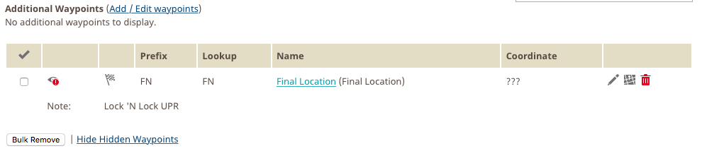
Ah, I see. So you are meaning just on your owned caches, you would like to see those waypoints that are hidden to other users?
-
Great idea. Goes along the lines of another user request that I got recently for a feature like this.
-
52 minutes ago, ShoesBologna said:
GC66R90
I am not seeing any Stages created for that cache, even on geocaching.com. I see them in the hint, is this what you mean?
If you created the stages as Waypoints when creating the multi then they will show in Cachly. Is this what you did?

List UI view
in Feature Requests
Posted
We appreciate your input!