Leaderboard
Popular Content
Showing content with the highest reputation on 04/03/17 in all areas
-
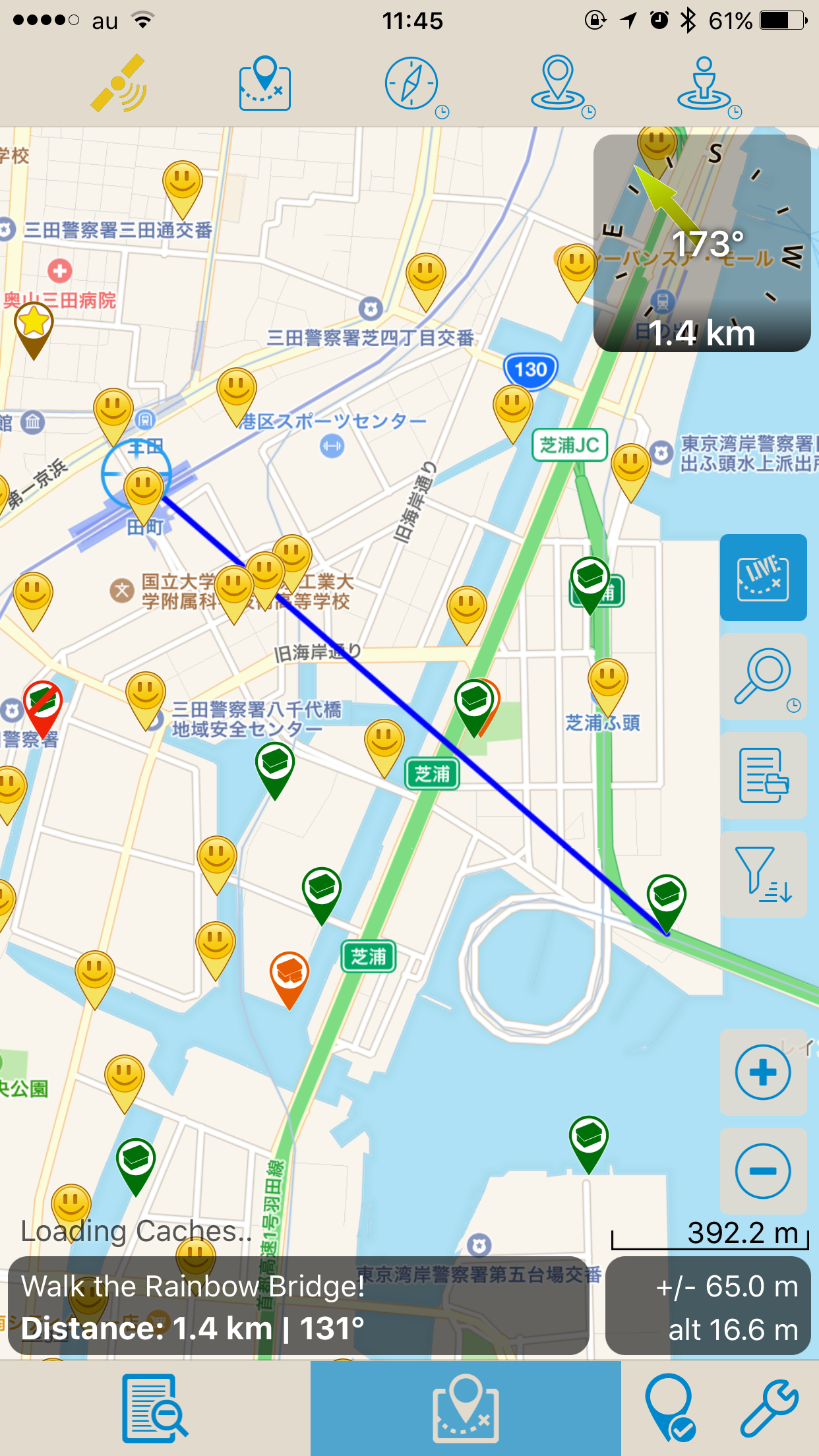
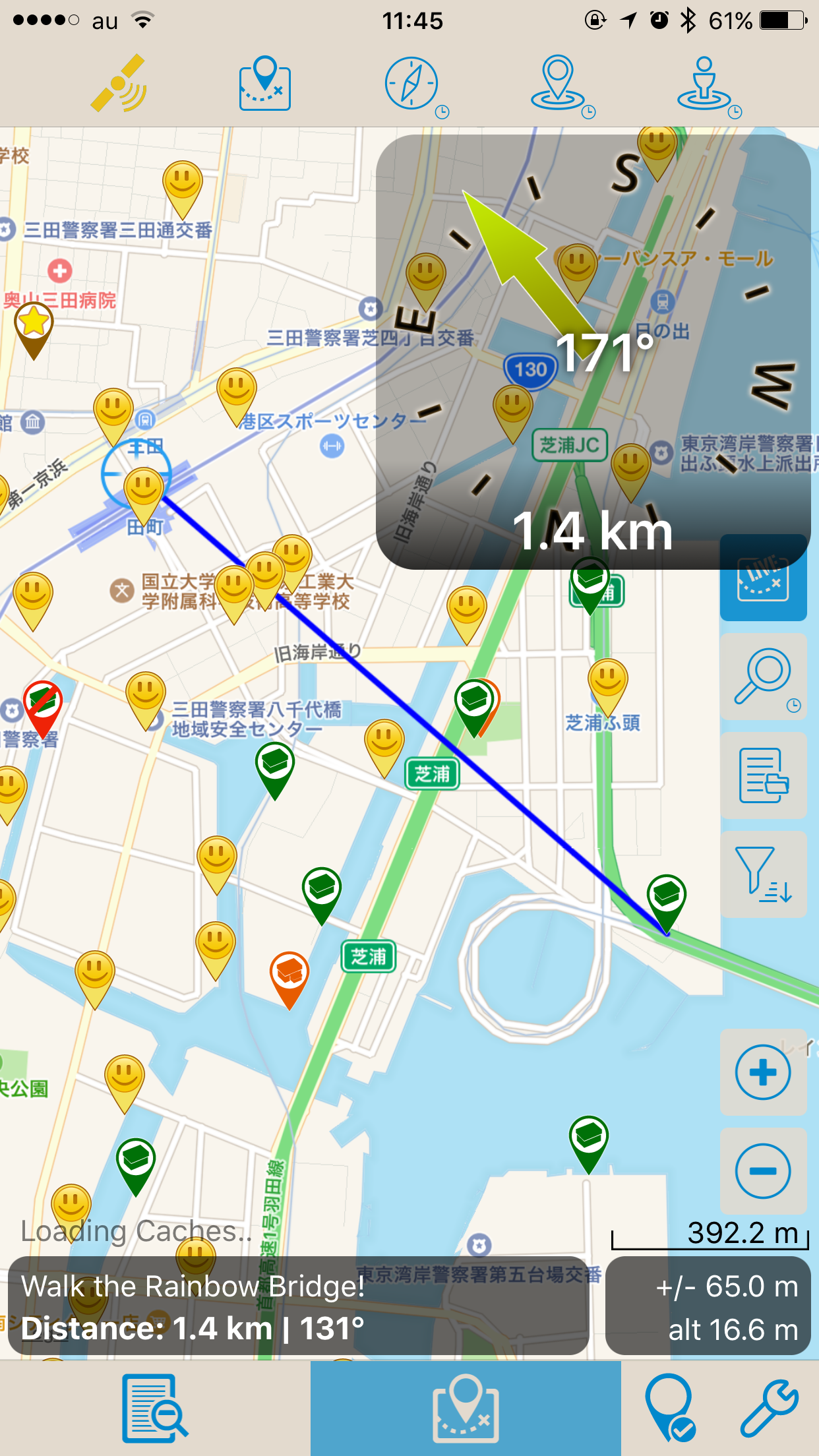
When deciding a cache or several caches to tackle next, having a direction from current position in the list view is helpful. It should update dynamically as you walk so you can see alternative caches at a glance and where they are (distance and direction) as you hike along.
 1 point
 -

Missing caches?
Nic Hubbard reacted to The_C4 for a topic
Also as dumb as it may sound, doublecheck the search filters! Just came from a series trail and while logging the stuff online was (un)pleasantly surprised to see that some of the caches were missed because I accidentally deselected "small" when fidgeting with filter settings.1 point -
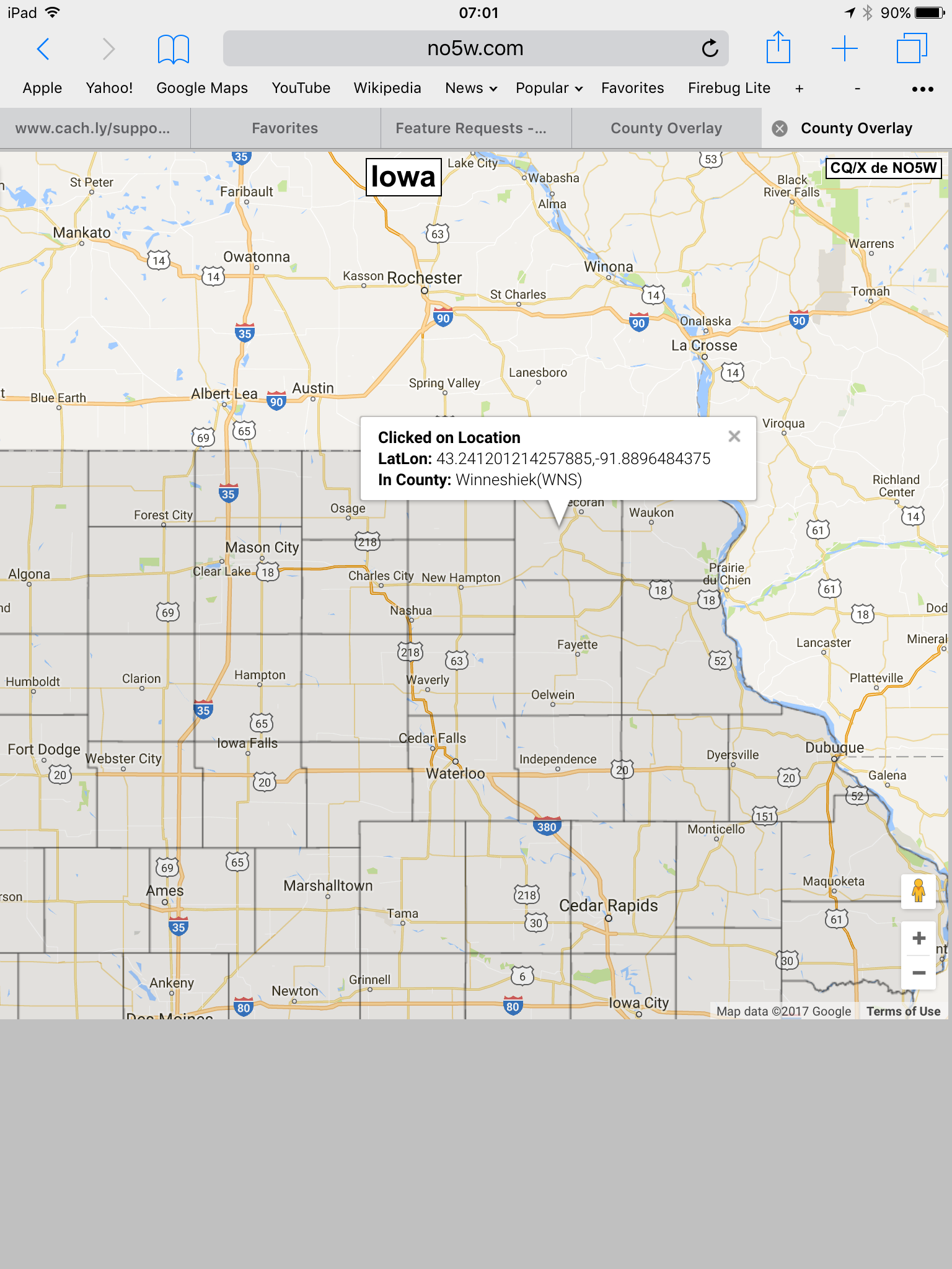
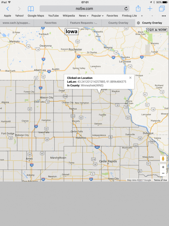
There are cachers who collect county finds. A map overlay that shows the boundaries of counties would be helpful in planning and when in the field. This would be an option you could turn on/off.1 point
-

County Boundary map overlays
Gdsdizz reacted to Nic Hubbard for a question
I agree the current solution isn't the best. Will revisit this.1 point -
Ah spotted them. They vanish if you are zoomed wide, turn to dashed orange lines as you zoom in and then go sort of solid brown as you zoom in further. Odd. I was hoping for something more like this. See pic.
 1 point
 -
Show direction in list view
Gdsdizz reacted to Nic Hubbard for a question
I like this feature as well, and have it on our list to add in a future version.1 point -
Compass on Maps
Hodějovice reacted to tonamigon for a question
When viewing a Live or Offline list, a mileage indicator is shown. Is there a way to provide a compass, which indicates both bearing and mileage from current location to the cache location? I have attached the screenshots of Looking4cache. This feature is quite useful. Thanks.
 1 point
 -
So I just used Cachly for the first time - primarily a Geosphere user. Here are a few things that I noticed, some of which I think would help the user experience. very easy to use and figure out. more intuitive than geosphere, definitely a lot better than the geocaching app. online search is faster than geosphere, and very usable when navigating to a cache, I like to have the little "fan" showing the direction I'm looking even in (and especially in) the case where the map isn't rotating. I don't like having to switch back and forth from the compass to the map to get that. In the case where the map is rotating, it is odd that panning the map even a little changes the mode (it goes back to non-rotating). zooming doesn't seem to change this. There doesn't seem to be a way to switch to "rotate the map to show my direction" and not, without also changing the zoom. crash importing a semi-large (~1000) caches. that was disappointing, but smaller lists seem to work. Geosphere's handling of very large lists quickly and efficiently is a game changer for geocaching, and is mentioned by others. parking coords for a cache only show up when you navigate to the cache itself, making it a little harder to find parking "in the area" if not all of the caches have that extra parking coord. My battery seemed to drop quite quickly. not sure if that was a coincidence or not. Anyway, it was a good experience overall - every program has its share of nits, so this isn't a complaint. Looking forward to testing it some more.1 point
-
In Geosphere waypoints are stored in the single unified local database, so it's easier to filter for additional waypoint like parking coordinates over the entire database and include them in a map view result. I don't know how Cachly does its local database search, but theoretically it should be possible to, for example, turn on the option to display additional parking coordinates stored in any list within a distance from some point being viewed, or in the map window. Personally, I have a category set up into which I've imported many thousands of parking waypoints I exported from GSAK, so if I want to I can toggle that category in the map view filter, and it'll include them all with whatever distance filter I'm currently using. eg, viewing all cache listings within 15km from my location, I can turn on additional waypoints filter, include my parking waypoint category, and then all the filtered caches and waypoints show on the map. It's a nice feature to be able to have a kind of secondary filter on additional waypoints over all the local data to be seen on the map (trailhead waypoints are also a useful option). Comes in handy in popular areas, when someone publishes a cache in a forest but doesn't put any additional helpful waypoints. This way you can see what other COs may have added to theirs nearby and make use of that info on the fly.1 point
-
Ah, I see. I never used that in Google Maps so I never noticed. It's not a problem, if the next issue is addressed. yes, I was using this. when you do that, it zooms out. So, if I get the map to look like I want (e.g. the cache I'm navigating to, within 500 ft, and I are in the map) and I want to switch to the mode where it points me in the right direction with the rotating map I can't do that. Hitting the location button zooms back out and changes the mode. once I get it back to rotating map, I have to zoom back in - and make sure not to pan at all or I have to do it all over again. as far as usability, I only really noticed the issue when I was close to the cache. iPhone 6. just used to geosphere where many 1000's are handled without an issue. it wasn't even a gpx file, I just hit the live refresh until there were about ~1000 caches and tried to add to an existing list which had about 500. that would be my preference, although I can totally see people thinking it would be too cluttered. thanks for the very fast response!1 point
-
First Use Experience
Gdsdizz reacted to Nic Hubbard for a question
Thanks for trying Cachly! This functionality matches that of Apple and Google map apps. This was specifically done to give a intuitive and cross app experience since users likely have used one of those apps. If you tap the current location button a few times it will toggle you through the different modes. One of which rotates the map as you rotate. Is that what you meant? What iPhone are you using? The import size depends on the amount of memory your phone has. As stated elsewhere we are working to fix this issue. Can you send me the GPX file? Would you prefer them to be on the main map with all the caches? Please let me know if you have any other questions. 1 point