

JohnCNA
-
Posts
15 -
Joined
-
Last visited
-
Days Won
2
Posts posted by JohnCNA
-
-
On 2/6/2018 at 11:04 AM, Nic Hubbard said:
Can you please send the GPX to me and maybe post some screenshots of what you mean by stand-alone waypoints?
How do I send a GPX? The forum software only accepts picture files.
Can you get it from my dropbox?
https://www.dropbox.com/sh/8xwchqdkm4r5wee/AAD4aiWnfA4kV57Ypy1V8OkVa?dl=0
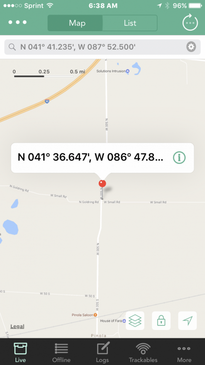
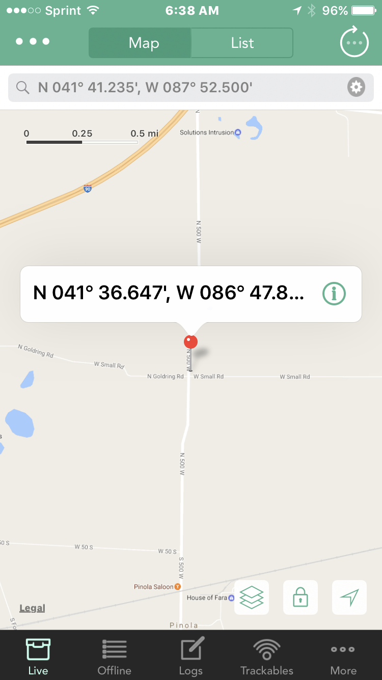
Here's a screenshot. The top 3 are standalone waypoints. Some of the geocaches did not have parking coordinates, so I looked the caches up on Google Earth and then manually added waypoints for the parking lots. for example.
I just got 4.0 installed, and it no longer crashes the app when I do a refresh on this list.

-
On 2/6/2018 at 11:10 AM, Nic Hubbard said:
This is on the list of things to address.
Do you sometimes update the corrected coords on geocaching.com?
Cool. Yes, I usually update the coordinates on the web site. I would expect the corrected coordinates to overwrite the coordinates in Cachly in that case. Or maybe have a dialog for yes/no. In my wife's case, the GPX I imported from Dropbox would already have the corrected coordinates, so a Refresh overwrites it with the original posted coordinates.
-
I noticed that if I import a GPX file that has non-child waypoints and then ask Cachly to refresh the list, it causes Cachly to close. If I go into the list and delete all the standalone waypoints and just leave the geocaches in the list and Refresh, it works fine.
Since we are a multi-device and multi-OS family, I usually create my GPX files in Garmin's BaseCamp or GSAK and then import to my Garmin, my Android app, and my wife's iPhone using Cachly. The problem is that I often add stand-alone waypoints to these GPX files like parking or trailheads that are not specific to one particular cache. These waypoints are not child waypoints of a geocache. And if I import such a GPX into Cachly, it crashes when I refresh the list.
The other odd thing I noticed is that when looking at the list in Cachly, these standalone waypoints show a location (or maybe it's a description) of "Cupertino". LOL
-
On 11/2/2017 at 3:59 PM, Nic Hubbard said:
Not too keen on allowing auto refreshing in offline mode. Everything in offline should have no network activity without a user initiated action.
Yes, auto-refresh can be a bad thing when there are corrected coordinates in the original GPX file. A switch or option to preserve corrected coordinates would be a good idea, I think. My wife uses Cachly but I create the GPX files with GSAK or BaseCamp (often with solved coordinates) and then import my GPX into her Cachly. If you run a refresh either on the offline list or an individual cache page, she will lose the corrected coordinates since they were not corrected in her online user account. Sometimes she will run a refresh to get the latest logs, but then lose my corrected coordinates.
-
On 6/11/2017 at 10:54 PM, hidegoseek said:
Try this: On the offline list choose a cache, then long press on its coords to copy them. Then move over to live view and paste those coords into the search bar. Make sure you're using the search bar option that accepts coords. It will then search live in that area.
That being said, I think there's a problem with the search using the format of the pasted coords. You probably need to delete the comma in the coords, and maybe even the apostrophes. (I think this gets fixed in 3.0.)
Coordinate search is not working. In the screen shot you can see what I searched for and what came up instead. Not even close. I edited out the degree and apostrophe and commas and it still didn't work. I see in the message above that the parsing is fixed in 3.0. Great! Search by GC code works OK so that's an acceptable work around for now.
-
On 6/13/2017 at 0:58 PM, Nic Hubbard said:
Do you mean from the Live tab? This has always been available by tapping the ... button on the top left.
Yikes. Once again I have missed something that should have been obvious.
-
It would also be cool at some point to have an option to add whatever is visible on the map screen to an offline list all at once instead of selecting them one at at time.
-
13 hours ago, hidegoseek said:
Try this: On the offline list choose a cache, then long press on its coords to copy them. Then move over to live view and paste those coords into the search bar. Make sure you're using the search bar option that accepts coords. It will then search live in that area.
That being said, I think there's a problem with the search using the format of the pasted coords. You probably need to delete the comma in the coords, and maybe even the apostrophes. (I think this gets fixed in 3.0.)
I'll give that a try. I was hoping for something in the list or description screen like "search near". Cachly is the only app we have that always goes to your current location when selecting Live. The others make you tap the bulls-eye if you want to do that.
-
I'm probably doing something in the wrong order but I can't figure out what I'm doing wrong.
I imported a GPX of a series as an offline list. I also want to check to see if there are other caches in the vicinity of this series. So I select my offline list, and the map shows the caches that are in the offline list. The location of these caches is 20 miles away from my home. What I want to do is use the Live mode to search this area to see if there are other caches near the series. But when I select the Live tab, the map moves to my current location. It looks like the only way I can do what I want is to pan the map to the area in question and then when Live picks up the surrounding caches, save them to the offline list. I could of course do this with a Pocket Query, but it would be easier and quicker to have the app do it.
Is there a better way other than manually panning the map to the area of my offline list?
-
I have seen some other apps that show all the waypoints, and show connecting lines from the waypoints to the geocache that they belong to. This is fairly handy when a geocache lists a couple of steps or trail heads. It helps to determine which cache the markers on the map belong to.
-
On 3/30/2017 at 11:11 PM, rragan said:
I often see 1-3 minutes for the iPhone app to settle down after hopping out of the car while GPSr users are off and running.
This is pretty typical of all GPS devices when turned on. You have to remember that most phone apps turn off the GPS chip when you are not actively navigating or viewing the map, in order to save battery. When I turn on my Garmin, it will take up to a minute to find the sats and determine it's location. The initial reported accuracy will be something like 90 feet or so. Over the next 1-2 minutes, the accuracy will fall to 2 meters or so. I have used quite a few apps on my wife's iPhone 6 and my Android phone, and the behavior is the same. The difference is that with my Garmin, the GPS is active whenever it's powered up. On our phones, the GPS does not go active until we call up the map or compass or select 'Navigate' to the target. And it will take 1-2 minutes to sync up and take a few readings to get it's position and accuracy down. And then with any of our devices, the magnetic compass is useless until we exit the metal automobile.
Try setting your phone to Navigate on the map or compass screen 2-3 minutes before you arrive at your parking destination. That will give your phone GPS time to acquire and settle by the time you exit the car.
-
On 3/23/2017 at 10:09 PM, Geoboater said:
Thanks for all your quick support; unbelievably fast and greatly appreciated!
Although something I've never done with GSAK (only used for challenge cache verificatin prior to this), I made a small GPX file there and was able to successfully import it. Since the individual geocaches have no common denomenator among them, I can't make a PQ to pull them. I'll see if it's possible to make a list on the geocaching site, import that to GSAK, then export to GPX and import into cachly. If the list option doesn't work, then I'll have to import each individual cache to GSAK as I did for the test file. Same result, only slower.
Geoboater, Cachly will import GPX files from GSAK with no problem. I had a similar issue with GPX export from BaseCamp, and found that if I loaded a BaseCamp export into GSAK and resaved it, Cachly imported it with no trouble. To add further praise to Cachly, I sent a Garmin BaseCamp GPX file to the developer and the next Cachly update would directly import a BaseCamp GPX without having to go through GSAK first.
- Nic Hubbard and ChrisDen
-
 2
2
-
I only see this option while viewing an individual cache listing. Oh wait, it has that option on the map screen, but not in the list itself. Well, that will work. Thanks for giving me the nudge.
-
I have V2.0.3 and can't find an option to refresh an offline database. I can only find an option to refresh a cache and it's logs one at a time. Has this been added yet or is it still in the future?
Standalone Waypoints
in Support
Posted
I have a problem with standalone waypoints that are not geocaches. When we travel, I create a GPX of geocaches and also add waypoints like a couple hotels and restaurants. I will either use GSAK or Locus on an Android phone. Then import the GPX into a Cachly offline list. The non-geocache waypoints are not displayed correctly in the offline list. The names get jumbled up and the details will refer to Cupertino Crossroads. Is there any way to get around this?