rragan
-
Posts
1003 -
Joined
-
Last visited
-
Days Won
75
Everything posted by rragan
-
I'm not sure if the API provides this but I sometimes want to restrict search result by region, e.g. Only caches in Florida. Right now I have to use the web site, construct a bookmark list, and import to Cachly. If possible, direct would be better.
-
Adding to this request based on something I wanted to do yesterday. When viewing Finds/Hides by Friend, allow export of the list and Add to offline. Ideally, all search result lists would offer the same actions on the results. I guess using Found By and Hidden By filtering on the Live search would give me what I want but looking for consistency. Low priority.
-
Recognizing coordinates in text contexts and making them clickable is related to the ability to generally recognize a coordinate in text form with support for the dd.ddd, dd mm.mmm, dd mm sss formats and associated embellishments like +/-, N,S,EW, °, '," Having this allows easier copy/paste entry of coordinates from other sources to make waypoints and corrected coordinates. Making the coordinate hot like a link lets a click trigger a menu with choices of Copy, Set as Corrected Coodinate, create related waypoint for example. I've mentioned this elsewhere but it bears repeating as several things get better with this ability.
-
Ah spotted them. They vanish if you are zoomed wide, turn to dashed orange lines as you zoom in and then go sort of solid brown as you zoom in further. Odd. I was hoping for something more like this. See pic.
-
I love the ability to see a friend's finds or hides. I know more extensive filtering is coming for offline lists. I would find it handy to be able to filter a friend's list of finds/hides for the things that make sense. Perhaps the same code can be used.
-
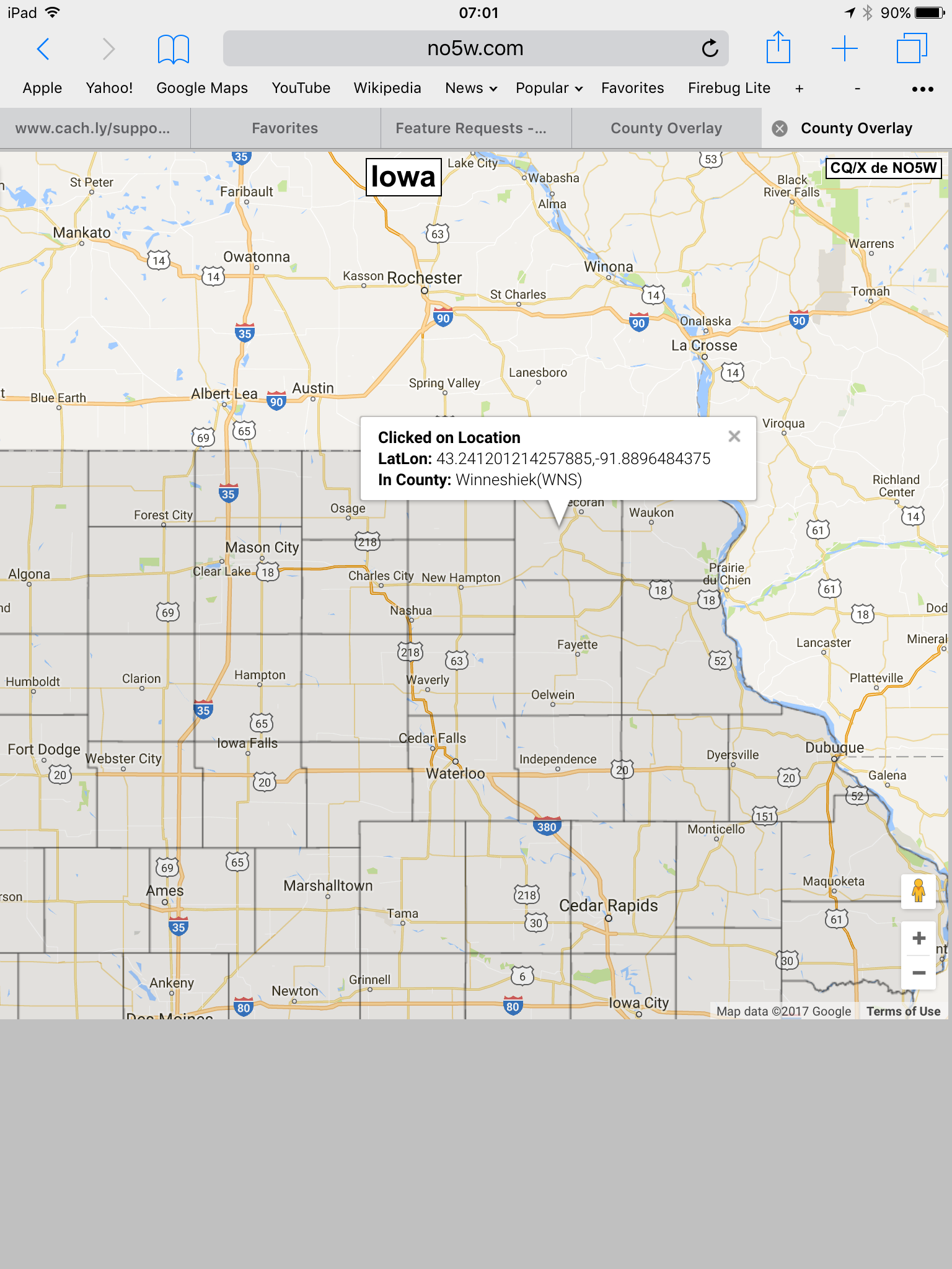
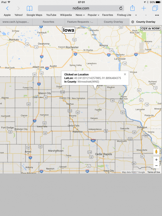
There are cachers who collect county finds. A map overlay that shows the boundaries of counties would be helpful in planning and when in the field. This would be an option you could turn on/off.
-
It is very useful to be able to see Street View of the cache location to get a sense of the location, parking options, etc. Either a built-in integration with Street View or bookmark support as mentioned in a different feature request would suffice. Thanks
-
When deciding a cache or several caches to tackle next, having a direction from current position in the list view is helpful. It should update dynamically as you walk so you can see alternative caches at a glance and where they are (distance and direction) as you hike along.

-
Artistic decisions are yours. I won't bring it up again.
-
I just updated the free app and see they have changed the icons. They are larger but I dislike the lack of ability to know where the cache is relative to the icon. I think they may leave singleton caches uncluttered but otherwise it looks like before. Wondering if you were tracking any coloring to be like what they do and if so, take another look. P.S. Earth caches should be brown if only one color is used for icons. I know... I've said it before.
-
I looked for a Refresh or Update action. Pull down was not intuitive enough though I am aware of it. Maybe add a backup menu item. Why shouldn't a successful drop remove it anyway? That seems like an obvious one to just handle.
-
Despite dropping for trackable's in my event, they still show up in my list of trackable's. The website shows them in the inventory of the event so they are being dropped properly but the Cachly list is not up-to-date anymore.
-
I am ecstatic. I wanted this but never figured it was likely to happen so I never asked. Is it SQLlite?
-
This just sort of felt like there ought to be a way to do it. Short story -- I got close but not quite. The problem is that Apple provides no way to write to an SD card from iPhone/iPad. Reading is also limited to pictures/video files with the special adapter. So I can't go directly from the device to SD card. I have a travel gadget that I dearly love for backing up pictures, setting up my own wifi network, watching movies off USB stick on up to 5 devices, acting a backup battery for other mobile devices, and more. This is the HooToo Tripmate: https://www.designernews.co/stories/9695-how-do-apps-like-lyft-uber-airbnb-skirt-apples-30-cut-on-each-transaction The iPhone/Pad talk to it via a HooToo app and a wifi network created by the HooToo. From the app I can read/write images to a file system on a USB stick which gives me backup and movie streaming. But it only accepts USB stick and the Garmin only accepts SD card. I hooked an SD card reader/writer with a USB connector to the HooToo and found I was able to write a file to the SD card but it had to be an image because Apple allows multiplie apps to access the photo library but in general, files belonging to other apps and non-image files cannot be shared. If HooToo supported writing arbitrary file types to the storage there remains the problem of getting the file from the owning app like Cachly to the HooToo app. This is technically possible if HooToo was registered as supporting GPX type which it is not. This is work I doubt they would undertake. If somehow one could fake the file type to be an image type and HooToo supported renaming files you might be able to do it -- but here I'm grasping at straws. I looked at AirDrop which uses Bluetooth and Wifi to transfer files in the absence of a data connection but you would need both protocols and proprietary Apple AirDrop info to pull this off. An interesting problem to research but I have no solution for you. Regarding AirStash, they seem to have moved away from SD card writing in their later products in favor of USB sticks so that is also likely no longer an option.
-
GeoohLive is an Android geocaching app so not direct competition for Cachly. The developer was on the latest CacheAManiacs podcast and did a detailed pass through the features. I summarized them for my Android friends. To save effort, I'm dumping the whole summary here but will annotate it with things I think would benefit Cachly. See my comments in parens after an item Geooh Live: Free geocaching app for you Android users out there. Summarized From CacheAManiacs episode: http://cacheamaniacs.com/ggh-271-geooh-i Interesting/unique features - Trackable code scanning built into app (iOS has TBScan as a separate app. I don't see gain from integration as this is a quite separate activity) - view of offline list with found, not found, count etc. with collapsible sections ( extended offline filtering might help with this. Not sure I want to split into sections as I may have other sort criteria plus the filtering going on) - Download external files to offline list: pocket query, GPX,bookmark list. Set status to "found" internal to app or upload and mark found. Draft log for offline. - Uses Live API, unlike c:Geo - Follows Google Material Design guidelines - Lists and Maps show if last log was a DNF (vs if my last log on the cache was a DNF. In fact, I would like both but tricky to depict) - Shows FTF marker if no logs yet (This is cool but not sure how valuable it will be to most people) - Log templates. Log header and footer from template populate new log being written - One by one or batch log upload - Enter waypoint to offline list or to its own list. Corrected coords show solved location and a waypoint for original location - County map overlay for US. Shaded if you have a find in that county. Long press to get county details, elevation at that location. 528' radius circles supported (I had thought of asking for this in Cachly earlier but was worried about source for polygons and space it might consume. It would be valuable to me) - Inside app see route, distance, ETA to cache per Google. Select multiple caches and get optimized route through them. (This seems to use Google features to accomplish. Not sure if IOS can get at it but routing is nice albeit hard) - Select cache from slide out list and center map to it (at least I would like a selected cache with flyout on Map to move the list view to that cache when I switch tabs and maybe blink it once to grab my eye) - Integrated Google Street View of location (Oh yes! I have a bookmark in Geosphere for this and use it a lot) - Hotspot view: identifies areas where lots of caches can be found - Option to control or disable clustering when there are lots of caches on map - Multiple turn by turn nav engines including Waze - Project-GC integration, see profile, see others profile (you have some of this with Friends) - Messaging to user but does via web page message center since no API (I do this via bookmark in Geosphere. Also email owner) - Show cache summary for the day, types, indication of any duplicate logs (Handy) Support unpublished caches. Load GPX with list of caches for an event or rally where those caches are not yet published. Allow all actions except anything that pushes data to the live site until the cache can be determined to be published. Support lab cache loading as above paragraph but perform change actions by loading a web view since there is no API.
-
A URL scheme is a way for other apps or just links in a mail to wake up another app and ask it to do something. So I could send you cachly://gccode=GC70 and you could click that and have Cachly open up to the oldest multicache in the world. Continuing with that line of thought, I have made a feature request to let Cachly users define their own "URL bookmarks" that would let Cachly integrate with other apps or web services. In Geosphere, I have a bookmark I defined that opens the cache location in Google Street View. Super useful.
-
Cache code case should not matter. Minor bug to fix.
-
Minor correction. Testing shows it only works if you omit the question mark before gccode keyword.
-
Cool. Somehow I missed that.
-
A URL scheme provided a great integration point with other iOS apps Add URL Scheme support for Cachly cachly://?<parameter>&<parameter>&<parameter>... parameter consists of <name>=<value> Allow <value> to be enclosed in double quotes if the contents of <value> does not contain a double quote. If <value> contains any reserved URL characters such as ‘/?&=#%,$+!*()[];:@ ’ then those characters should be URL encoded. Supported forms: Start Cachly No parameters Example: cachly:// Set Target Waypoint and open to cache view Examples: cachly://?target=GC12345 Set named location location=<latitude>,<longitude>&title=xxxx Coordinates are in decimal More features could be supported but this is a great start.
-
The current text on trackables is confusing. I looked at one in my inventory which was recently discovered by xnard. The status message says "Last seen with xnard". This made me think somehow it was in her possession. Saying "Last discovered by xnard" would eliminate the confusion.
-
I was using an iPad. I tried it again this morning and it no longer does that. Focus goes to the pin and stays there. Gremlins. I'll keep an eye out for it.
-
I had hopes that the saved locations might help with this. When you drop a pin and name it, you can find it in the Saved Locations list. You can name it anything you want so you could invent prefixes to meet your need. Where this is not quite enough is having an option to show saved locations on a map. I can see any one but not all at once. Nor can I search saved locations by name, although you would need a bunch before this gets interesting.
-
When I enter a coordinate like N 037° 00.000', W 121° 30.000' in the search field, a pin is dropped but the map view zooms to somewhere in the North Atlantic. I'd expect the focus to be on the pin.
-
Save them in an offline list with a name like "clues" and put text in personal info. The ability to associate private images with a cache is a different feature that has been requested.