

Nic Hubbard
-
Posts
3845 -
Joined
-
Last visited
-
Days Won
388
Posts posted by Nic Hubbard
-
-
4 hours ago, Vasco Galvao said:
Is it possible to purge logs?
i really need to purge my database and i don’t know how to do it.
No, this isn't currently possible.
-
IMPORTANT:
The old geocaching.com API will be shut down on June 3rd, which means you must be using Cachly 5.1.4 to continue to use the online features of Cachly. (Pre 5.1 versions such as 5.0 will work as much of it was on the new API, but some things like trackables and waypoints won't). Version 4.x will no longer work for any API related functions.
Please upgrade to Cachly 5.1.4 as soon as possible. We support devices that are on iOS 10.
-
We released Cachly 5.1.4 yesterday. Make sure to download it as it should fix these issues.
-
3 hours ago, NLBokkie said:
Do you know of any plans of Geocaching.com making changes to the API to include lab caches?
No, I don't have any knowledge of this.
-
You can duplicate the cache waypoint which will bring up the screen that allows you to set it as corrected. Have you tried this?
-
-
15 hours ago, frso80 said:
Would it be possible to add two icons on the map an + and - so you can zoom in/out by clicking them?
No, this would clutter up the interface. You can double tap to zoom and two finger tap to zoom out.
15 hours ago, frso80 said:Also I noticed that this double tapping and move up and down to zoom in and out worked on the premium offline maps.
")
Yes! This works in Premium offline and Google Maps.
-
15 hours ago, frso80 said:
200 000
Wow, Cachly was never tested with that many caches, cool to hear it still works!
15 hours ago, frso80 said:It looks like the video is private. Can you make it public so we can view?
-
20 hours ago, teammoehrke said:
it doesn’t change whatever is defaulted to when I paste new coords in, and then doesn’t keep the one I edit to. Seems to only affect the North coords, not the West, at least here at GeoWoodstock.
This sounds like a different issue. Can you explain a bit more?
-
This will be fixed in a future update.
-
7 minutes ago, Mister Doctor said:
I’ve updated to 5.1.2.
I think the issue is the same. I do see all my saved waypoints on start up, but if I add a new one it is initially there with the rest but they all disappear if I leave that cache and return.
If I quit out of the app and restart it all the waypoints are back again, including my newly added ones...
Can you please confirm if this is in offline or live?
-
Do you have the Settings option "Fit to Map" turned off? If so, it looks like there is a bug causing what you are seeing if you have that option off.
-
That is strange. Can you let us know the GC username and show us a screenshot?
-
Was this for live caches or offline?
We had some fixes for waypoints in our 5.1.2 update, make sure to update and see if that fixes the issue.
-
Email Support option is tied to your iOS email setup, so if you don't have anything configured there you aren't able to send. Feel free to email support@cach.ly or let us know your question here.
-
This issue has been fixed and will be included in our 5.1.3 update.
-
There is a bug currently with the find_count keyword. We are working to get this fixed.
-
There is a bug currently with the find_count keyword. We are working to get this fixed.
-
When you view the pending logs, do those logs have log text when you view them?
-
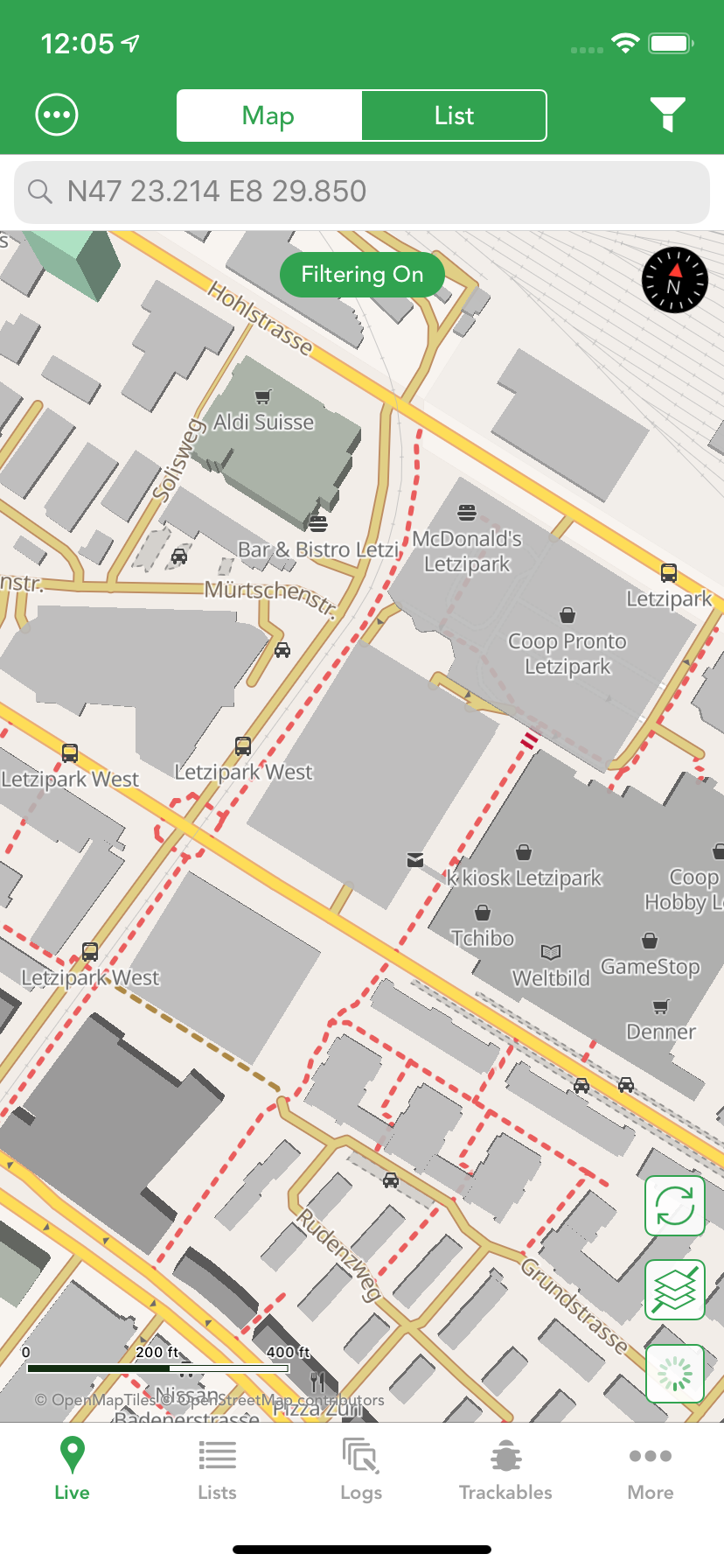
12 hours ago, Attila_G said:
This sign is missing on the new maps.
New maps use an icon of a car for parking as well as filling the space with color. Do you have a specific location where you see parking lots missing? I have never seen missing parking lots.
12 hours ago, Attila_G said:On this section you can also see the three bus stops, which are not shown on the new maps.
You must have some map layers turned off such as Points of Interest. Check your Settings and make sure that is turned on. It is on by default:
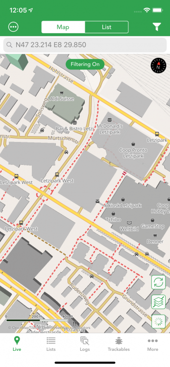 12 hours ago, Attila_G said:
A quick look at the old map shows me that there is a forest house and a parking lot. On the premium map I have no idea what it should be exactly. The Freizeitkarte-osm.de would also show a fountain with drinking water at this site.
Please make sure to turn on the Points of Interest layer, so it shows the data you are missing:
-
3 hours ago, Attila_G said:
In Switzerland, this means that only local residents or delivery services may drive on these roads. For all others there is a driving ban.
Thanks. This is something I will be happy to add in a future version.
3 hours ago, Attila_G said:And of course parking lots or bus stops are also important information.
You are seeing parking lots that are missing? Which coordinates is that at?
-
33 minutes ago, DrDaffy said:
but would it be so hard to implement point 1 and show the name of the marking color in the cache details?
It would not be hard at all, but I have worked vigorously to design the UI to not be cluttered and I think in this case showing the user definable label would clutter up the interface.
-
16 minutes ago, Attila_G said:
If needed I can also tell you the coords of this locations.
Yes, I would need coordinates for all of these examples.
17 minutes ago, Attila_G said:restricted feeder service.
I am not sure what this is?
17 minutes ago, Attila_G said:Free-standing trees are displayed.
A bench seat is also visible.These sort of additions would make the offline map database sizes much too large. Image how many thousands of tree objects might be in OSM for a country. We have purposely omitted certain things like this.
18 minutes ago, Attila_G said:numerous inscriptions on public buildings.
House and buildings numbers are omitted as it is unnecessary data to make the database larger.
-
5 hours ago, DrDaffy said:
Starting on the map I see a cache with a black marker, but have no clue what it means (Screenshot1). I open the cache details, see that it's marked with the black marker, but I still have no clue what it means (Screenshot2). In order to get this info I have to edit the marker of this cache (Screenshot3) and finally in the list where I choose the color for this cache I can see the meaning of this marker/color.
At least that's the only way I found.Since these are user definable label names it is up to the user to remember what custom names were given.
5 hours ago, DrDaffy said:I think it would be great if these markers were used like tags and you could assign several tags to a cache. I attached an edited screenshot (Screenshot5), which might make this clearer. On the one hand you can see what the markings/tags mean (see point 1) and on the other hand it shows a cache to which two tags have been assigned.
I do agree this is a nice idea! However at this point it isn't built in a way that could easily accommodate this change.
Thanks for the suggestions!


Stop Cachly from zooming in when i set it to track my movement.
in Feature Requests
Posted
I agree there is room for improvement. I will look at past a certain zoom level, only center the map and don't zoom in. Meaning, if you are looking at the whole world, tapping the location button would zoom and center. But, if you have already manually zoomed in to a certain level, Cachly would honor that level and just center the map.