

Team DEMP
-
Posts
619 -
Joined
-
Last visited
-
Days Won
58
Posts posted by Team DEMP
-
-
Give iPhone Mirroring a shot. I used it last weekend after coming home to finish logging. https://support.apple.com/guide/iphone/control-your-iphone-from-your-mac-iph505911a40/ios
Another option is to create logs in Cachly and enable the Save as Draft option. This will upload to the Geocaching website where you can elaborate on your log before final submission. https://help.cachly.com/article/108-online-drafts
-
One consideration would be to create a list of caches that Need Maint and select/ display the list as needed. You could add all your own caches to a list and use highlighting for any needs Maint, or just use the list for caches needing maintenance.
-
Sounds like an issue with Google Maps. It is controlling sharing CarPlay. It works as you want for me running Google Maps, Apple Maps or Waze, the 3 nav apps I have installed.
Maybe reboot your phone and try again?
-
The Geocaching app is functioning the same for me - nothing different.
If you are connected to CarPlay and in Cachly launch navigation to any app that supports CarPlay it should just show up on your cars screen.
-
I don’t believe that is a function of the geocaching app. If you are connected to CarPlay, it should work fine in Cachly. I use it all the time with CarPlay.
-
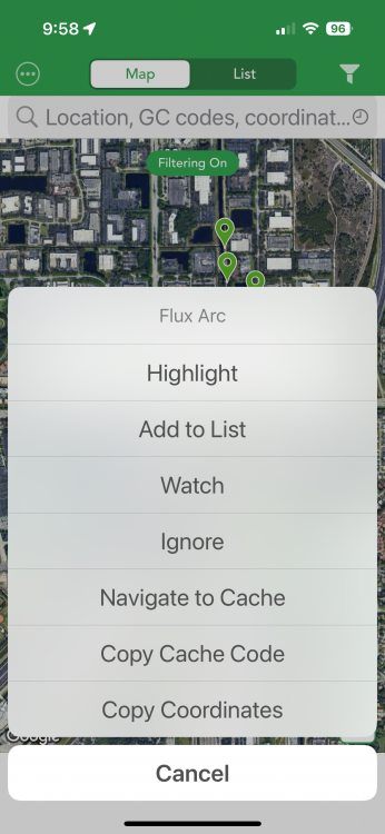
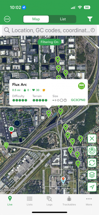
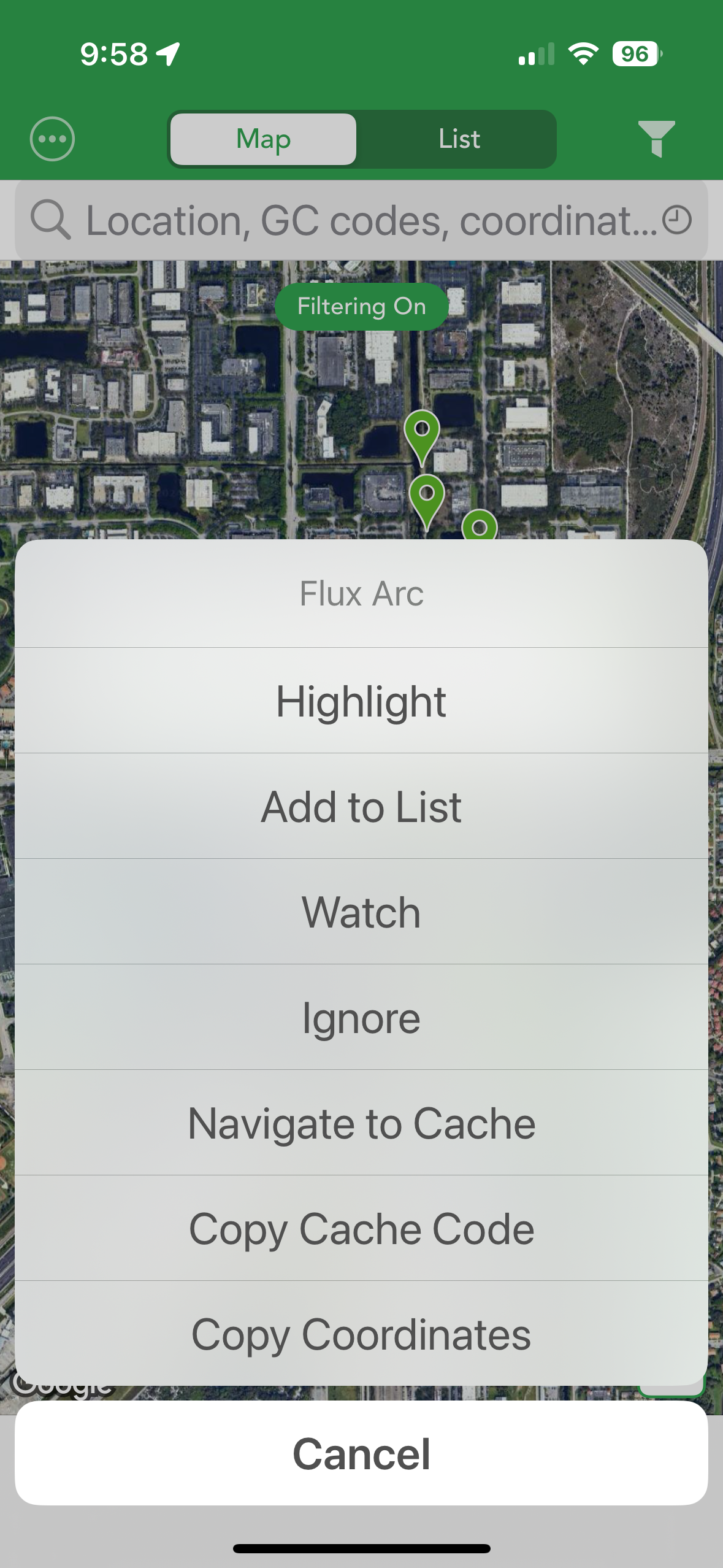
The official app seems similar to me but maybe I'm missing your steps. There is a car icon that launches a list of navigation/routing apps and when you select one, it launches that app w/ routing directions, if the app supports routing. Cachly is the same for me once you select the Navigation icon for the cache. There is also a shortcut on the main map screen that if you long press the callout for a selected cache, you have the option to Navigate right from the main map screen without going to the cache first. See the screenshot I will attach.
-
Hmmm - I dont even show a sort option for online lists. If I select Online, the ... on the top left is removed and the only option is to create a new online list.
-
Try to go back in again to sort and this time just click Title. Clicking Title again will sort in reverse order. Clicking Date first will sort by date, so go in and just select Title as the sort. Does that work?
-
Watch the video at https://www.dropbox.com/scl/fi/xxxz0qq2ahjs7wpqvlfli/RPReplay_Final1720484948.MP4?rlkey=desgzz9mltmlrwljgjzjiwyls&st=zp4o825j . It takes 3 seconds to add a highlight to the cache you just submitted a Write Note for. Lets round up to 4 seconds. if you need to do this 15 times a day, which is more than the number of challenge caches you logged in any one day based on your stats, that adds up to, drum roll, 1 minute.
1 minute at most during your entire day. Probably 5-10x less than it took to post your last reply, taking shots at me and my suggestion, but nothing personal. Good luck. -
Geocaching.com provides this feature. I’m not sure Cachly can as it only accesses the geocaching data when you make a request in the app. At that point you’d see the FTF icon displayed on the map.
-
I have more than half the number of challenge caches found as you. I’ve been playing for 21 years. Does that help?
-
A Write Note isn’t a Found so I don’t see why both would mark a cache as Found. It appears you want a visited indicator which is only needed for a cache you want to and’s write a WN log for without logging it as Found? Highlighting sends the best for those few exceptions you might have and there are multiple ways to quickly highlight off a list of live view. Yes it’s another 2 taps but not a burden.
I thought of another option… log them all as Found but disable the Send Now toggle. All caches will be marked as found and then you can go back through the pending logs and review/adjust each before sending.
-
A couple of suggestions/options...
1) I mark challenge caches that I qualify for by updating the coordinates. Qualified challenges show with the corrected coordinates mark and those I don't show without. I log those that have the corrected coords and I leave a Write Note for those I don't. For those that I do qualify, I usually have the Personal Note updated with the text to copy into the log to show I meet the requirements, such as the text from PGC checker.
2) You can use highlighting to temporarily mark caches you visited if you are just looking. for a visual indicator on the map/list in Cachly.
Other folks might have other suggestions. -
Once a template is inserted, changing the log type will not change the log text, whether it was just the previous template or the template + any additional text you might have typed.
You can highlight the templated text and delete it and then from the same data entry screen, tap to bring up the context menu, scroll to the right and select Insert Text Template and select one of your templates to insert.
You can also turn off setting the default log type as well as inserting any text automatically and use the above method to insert a specific template based on your situation. -
21 minutes ago, dabayer said:
And the best, i can set the coordinates as new waypoints
What is the question/need you asked above in your original post on setting coordinates as new waypoints?
-
I don't use it but I believe Cachly Pro supports Family.
On a phone not yet enabled for Pro try going to the ... More screen (bottom right of the main screen)
Then Tap into Settings
Scroll all the way to the bottom of the Settings screen and there is a Restore Purchases option - tap into that
Does the new device now have access? -
For your comment on coordinates, if the coordinates are in a field such as personal note or elsewhere, they will be underlined. If you tap the underlined coordinates you can create a waypoint, set as corrected coords, copy them, navigate to those coordinates, etc.
Not sure what you mean by a formula calculator. There are a few apps, some free, that focus solely on "tools" for solving, etc. Check out apps like GC Wizard and others. There are also online sites specific to puzzle solving, etc. -
Are you on the Live map?
Long press the funnel icon in the top right and that long press toggles filters on/off. Long press so Filtering Off is displayed and the funnel is no longer white. Try to load where you believe there is an AL. Does it display? If so you have some filter option that was preventing it. -
I run at a larger size too but maybe 1 less then you, and most things fit fine.
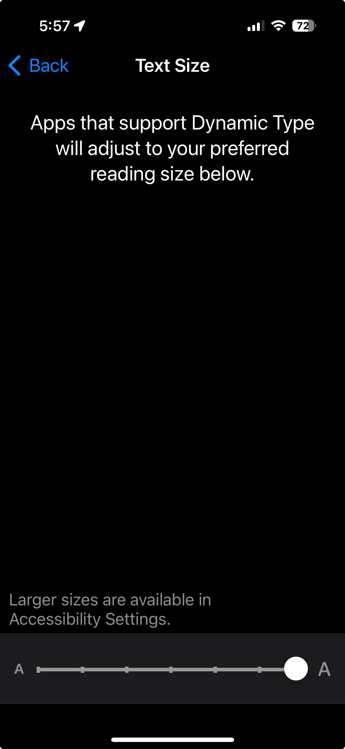
If you go to your iPhone (not Cachly) Settings and pull down to search and then enter in Text Size, I run at the setting all the way on the right. That is the largest setting on that screen.
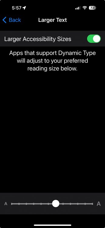
if you had gone into the "disabiities" settings and enabled large text there, that would put my text size in the middle of the possible sizes. I suspect that is what your settings are currently enabled. I have no idea if adjusting it down a bit would still be usable for you, even if just while you are using Cachly.
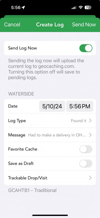
Here are some screen shots that show what I referenced above:
Cachly log screen with my settings:
This is the Text Size setting screen and I have it set all the way to the right:

This is the screen after enabling Larger Text in the disabilities option. It puts what was the largest setting in the screen above now in the middle of how large the text could be:
-
No problem at all. Have a great rest of your weekend.
-
2 minutes ago, forest-ghost said:
Also, when I went to delete the individual state map for MissourI I was unable to do so.
I can delete the contours but not the state map.
You can't delete the active map. You need to make a different offline map active or an online map such as Google or Apple and then you should be able to delete any offline map.
-
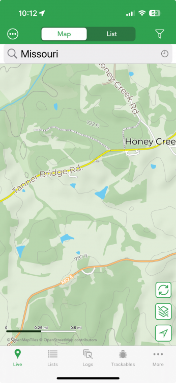
I download MO maps and I see the topo/contours in various places such as just south of Jefferson City. If you go to this and zoom in so you see what I show below?
I wasn't clear if you also downloaded Washington State and you see the elevations there and just not in your Missouri download?
-
After you downloaded the base map, did you also download the Extras Contours & Hillshades for the state/region? if not, go back into the maps download area and select North America / United States and under Washington see if there is the download icon for Contour & Hillshades and download that too.
-
It isn't recommended to use display multiple maps simultaneously as the behavior you reported could occur. This was true even with multiple maps under v7.
Is there a specific reason you want multiple maps loaded at the same time?


Cachly on macOS and syncing Pending logs.
in Feature Requests
Posted
Ah - I wasn't aware screen mirroring was region specific. I missed your initial comment on using web drafts as I replied early in the morning from my phone and overlooked that point.