

geo-knot
-
Posts
31 -
Joined
-
Last visited
-
Days Won
2
Posts posted by geo-knot
-
-
Ah! Much like elevators in Europe where the ground floor is zero. Interesting. In the states, when people say "oh, it's a 5 stage multi" it means that when you find the 5th thing, you have found the final. I know L4C starts it's numbering new waypoints with 1 which has always thrown me off.
-
There are tons of map options available now which is awesome! My problem is having to hunt for the two or three that I use all the time has it gotten a little harder. It would be awesome if we could edit and re-order this list to put our favorite maps at the top, and hide ones that we never use
-
It would be cool if when you were creating a waypoint if there was a default name filled in. The first one could be called “stage 2” the second one could be called “stage 3” etc.
Note that the first waypoint. Created starts with the number 2, this is because when doing a multi, the listed coordinates are usually stage one.
Of course if someone wanted to change it to a more meaningful name, they could.
-
OK, just thought I'd give you a heads up. Incidentally, you probably saw in the screen recording where things start to move about half way through. The blue dot accurately reflected my location. The red line seemed to be doing its own thing which did not quite compute. So it's not totally clear to me that the map was off here.
-
This happened again today. This time I took a screen recording of it. The line was going to a completely different place and just hanging out there. Really strange. It was on a google map when it happened. Then I changed to an apple map, and the problem went away. I switched back to google, and it was fine.
I uploaded it to dropbox here: https://www.dropbox.com/s/mp6dg6ehnrskry0/ScreenRecording_03-14-2019 14-31-49.MP4?dl=0
I won't leave it there forever, so if you want it somewhere else, just let me know.
Ben
-
Thanks David, that's exactly what I was looking for. I was expecting it to be on the "..." next to the list name.
Ben
-
Is there a way to "refresh" an offline list all at once to pick up corrected coords, new logs, and anything else that could have changed? How about images?
Thanks, Ben
-
I'm also coming from L4C, so I know exactly what PlasmaWave talking about. It's a nice feature. He is talking about the main (or first) map screen. Tapping on a cache will also show it's associated waypoints, and from there you can select a waypoint to say.... navigate to it. It cuts out a bunch of extra steps. Kinda what I was trying to say initially here.
If you decide to implement this, you may like to make it so that when you click off the cache, and the call out goes away, the extra waypoints stay on the map until you click a different cache.
-
Interesting, I saw this one today. I was fairly zoomed in, but it did not self correct quickly as I was expecting. It seemed to stay like this for several seconds with little change.
-
Cachly v 5.0.3(2) iPhone X IOS 12.1.4 I think I found a bug...
from the map, choose a cache, then navigate to the cache.
On the resulting map, choose a different cache with a different owner, and click on the call out to view it's page.
Hit the back arrow on the top left until you get back to the first cache and select "log geocache".
at this point my template which contains *|owner_name|* will translate to the owner of the second cache, even though we are trying to log the first cache. Not sure which cache actually gets logged since I caught this before I hit send.
Ben
-
here's one: GCXE6G . There are a lot of these around. It is a bit of a pain to have to check the preview for every cache.

-
I think this may be a minor bug...
When I start to edit my log text (pre filled with a template) the cursor starts at the beginning of the text. When I go to "..." and select "Insert Text Template", it inserts the text at the end of the text instead of where the cursor is.
Incidentally, I'd rather that I had a button "Replace Text With Template" to wipe out the text that was there with one of my templates.
-
I love the variables in the log templates, but I sometimes run into a problem... I use the *|owner_name|* which uses the owner's name as listed on the cache page. The problem with this is that a significant part of the time, it comes back as someting like "user1 (adopted by user2)" which does not really fit into my sentence thanking the cache owner. When I used L4C, it would convert the templates when you begin to create your logs so that you could see if it was right, and correct it it it was not. Even better was Geosphere (back when it was the best thing going) It had two variables available. One for the cache owner as it was listed on the cache page, and a second for the cache owners username as it appears on their profile.
This second option would be the best, because it calls out the current owner. But if the API no longer allows for that, perhaps there is another way... If you replace *|owner_name|* with the owners name at the time you click "Log Geocache", then you could easily see that there is someting that needs to be edited. I understand it may not make sense to convert all the variables at that time, especially ones relating to date and time since they can still be edited.
I also understand that I can always click "Preview" to see how my log turned out, but that's a lot of effort for every cache when I'm using a feature that is supposed to make this part faster.
Thanks, Ben
-
Project-GC also recognizes {FTF} or (FTF) without the * . That may be the easiest solution.
-
I would not say always, but I have noticed it before. And yes, it generally self correcting. Interesting, it seems that the map framework has some built in averaging.
-
25 minutes ago, Nic Hubbard said:
What map type were you using?
Ah! I was using Google Standard Maps. I just switched to Google Standard and tried it on GC26PZ5 and was able to reproduce the problem.
-
Just tried it now without restarting, and it worked fine. I guess the problem is intermittent.
-
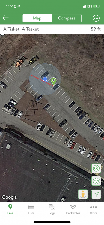
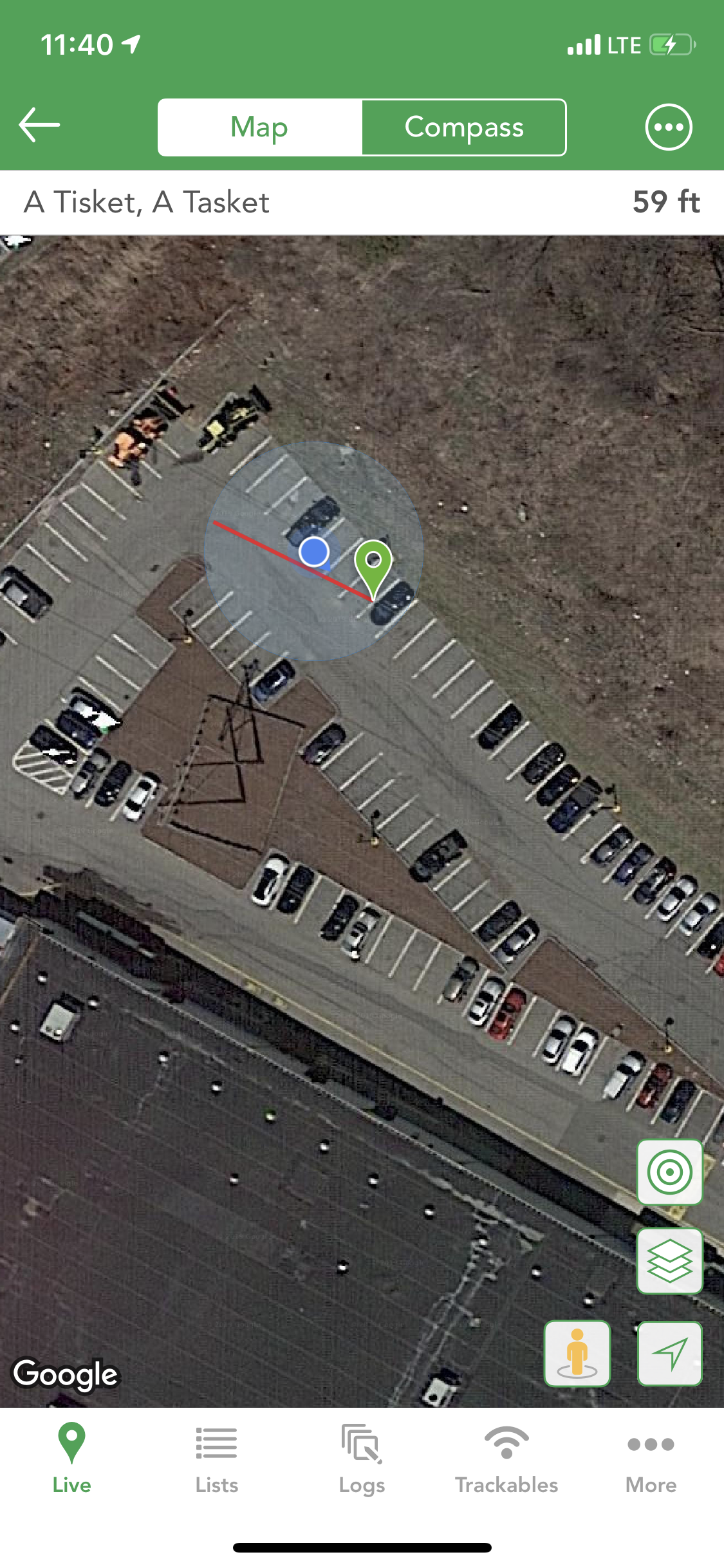
Perhaps this is by design... As the GPS gets a better (or worse) signal, the blue dot slowly drifts around as if it's position is an average of the last several readings. The red line on the other hand seems to update abruptly. The result is that the line and the dot sometimes don't line up which can result in a somewhat confusing situation. (see image)
-
I started by navigating to GC217J4. Now I want to get driving directions to the parking coords, so I'm trying to set the target as the parking coords, by clicking on the parking pin on the map, then the "...", then "set as target", but nothing happens. It looks like the "set as target" button might be greyed out, not sure.
I am able to set it as the target if I go to the list of waypoints, then select that parking waypoint. Note, on this resulting screen, the only pin on the map is the parking, no others, but this seems to be the current implementation. As a side note, maybe we could see other pins on this screen too.
-
I guess there are two issues here now.
- waypoints disappearing altogether
- some or all waypoints show the apple default pin.
I've seen both a few times. I'll see if I can figure out any patters. If I do, I'll report back.
-
gee, I see I have the 5.0.1 version now, but I think it was just the 5.0 then. I did it right after the new version came out on Sunday, so it's probably all fixed.
-
FYI, I selected the big tip when purchasing the premium maps access, but for some reason, when I got my email receipt, it looked like it did not add any tip.
-
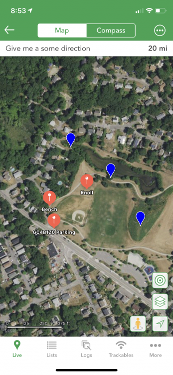
GC4B1Z0
After I ran into that problem, i found another possibly related one, at one point, some of the user waypoints showed up with a different icon and a label. (See picture) Soon it resolved itself and they were all blue. But I had seen some of these red icons before earlier in the day for cache waypoints and was not sure what was going on.
-
On the screen when you are looking at the main map to choose which cache to find next...
It would be cool if when you click on a cache and the information pops up about the cache, any additional waypoints for the cache would also pop up on the map. That way if there are parking coords, or other important locations, you know about it right away rather than when you navigate to the cache. I realize this won't guarantee that the waypoints won't be hidden by the info pop-up.


weird object icon showing after spoken logs
in General Questions
Posted
I'm getting the same thing in any log where I dictate text, which is any log where I change the template. At first I just went in and removed all the OBJ/new line character manually, but that got old quick. I'm using the default iPhone keyboard and use chrome on the desktop. Has anyone come up with a solution?
I just did a test where I deleted all the text inserted by the template, and dictated "this is a test." , and the OBJ still showed up at the end.