Thot
-
Posts
93 -
Joined
-
Last visited
-
Days Won
1
Posts posted by Thot
-
-
I receive text notifications of new cache approvals. Is there a way to have Cachly select the cache in the text message?
-
On 7/1/2019 at 2:06 PM, thelinuxnoob said:
You can get an email notification sent via text message if a cache is placed within a predetermined radius of a specific location. That's the part I find sort of inconvenient. I had hoped to be able to simply enable a setting that would notify me if a cache was placed in my vicinity.
Please do not take this as a snarky comment. I wondered how a radius from your location is different from your vicinity?
-
I was updating a webpage just now and wanted to see how it looked on a phone. I used cachly to go to the page. I saw something that needed improving. I made the fix. But when I tried to view the fix I was unable to refresh the cache page. I had to remove cachly and reload it to refresh the page, so how is this done in Cachly?
-
Thanks. That did it.
Now I have trouble getting back to the main Live screen.
-
I may have asked this before. If so, I don't remember the answer.
Once I'm navigating to a cache, how do I switch to Google Maps for turn by turn navigation?
-
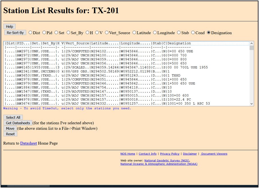
After you choose your state and county it can take several minutes for it to create the list of benchmarks -- see attached screen capture for what the list looks like. I've never seen this step fail.
After that you select some number of marks and download them. If it fails you selected too many, try again with fewer. I then combine the bites in a text editor (Notepad in Windows). I'm not sure it' necessary but I remove the extraneous stuff.
-
2 hours ago, elrojo14 said:
I just tried to download my county and man it is taking forever. I suppose some counties in the US are larger or smaller than others. Mine is pretty large.
In fact, it finally got there and then when I tried to select them all it gave me this image below.

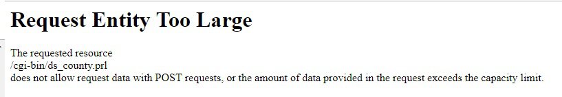
I can't download my county in one bite either. After you choose the county and get the list of benchmarks you do them a piece at a time. Highlight part of the list and download that, then take another bite, etc until you get the entire county. You have to keep track of where you started and stopped last time to avoid duplication.
-
It seems you have to tap the arrow button for each cache. Is that correct?
-
I have now updated to the latest version, but I will not be able to replicate the failure because I had never experienced it before.
I may have mentioned this in a prior post, but I normally only use Cachly when I'm at a cache I can't find and need to look for spoiler pictures and logs.
Today was the second time I had used it to go to a cache and I used it for 3 caches, because they were not in my Nuvi or handheld. . I was only able to use the distance to go to them. It was the third cache where this thing happened, so Cachly had worked properly twice earlier.
-
There is the more button and the arrowhead on the bottom right. Do you mean the arrowhead?
- Cachly version number I suggest you explain in Posting Guidelines and in your online help where the version is
- iOS version 12.1.4
- Device that you are using iPhone
- Screen that issue is happening on and if you can replicate it
- If you are a Regular or Premium user of geocaching.com Premium
- GC code if your question is about a specific cache
-
There was no back button/arrow and yes I clicked the Live box on the bottom left
-
Which button?
-
I did not move the map. I assumed it would follow me. Did you miss where I said it was pointing directly behind me to the target behind? Given it was pointing in the opposite direction I figured it was useless anyway.
I did try to go to Google maps but having not done it before I couldn't figure out how to change it to navigation while in traffic. Now that I'm home I now see how.
I had never used Google navigation before
-
After I reached a cache, its name was still at the top of the display but I was unable to get off that screen or back to the Live display (screen with the collection of caches showing). In order to return to the Live display I had to close Cachly and restart it.
-
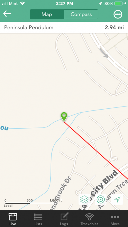
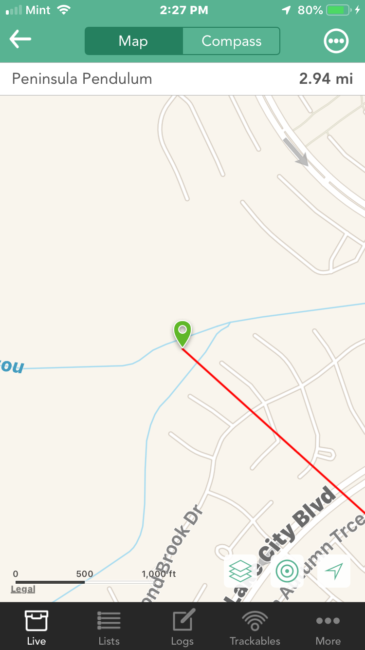
For the second time today, I tried to use the Navigation function. After selecting my car and the target were on the screen, but the target was 2 miles directly behind me as I moved out. The distance to the target worked so I used that but as I got withing about a mile, neither my car nor the target were on the screen. I continued to use the distance which took me to the location but for a mile or so the car and target were still not on the screen and they were not present when I reached the location.
-
I realize this may be too difficult. I used Cachly's navigation to the cache for the first time today. It simply points a straight like to the cache -- like the map function on a handheld. It does not tell you the route. That is, which streets to take and where to turn, etc. If it could just show a zigzag path it would be a big help.
-
On 12/7/2018 at 10:34 AM, elrojo14 said:
There is absolutely no good benchmarking app for iPhone nor really anyway to download benchmark data and display it in an app for paperless benchmarking either.
On 12/7/2018 at 11:58 AM, Tung8 said:elrojo14 asked me to post a link to the State benchmark datasheets. You can download the entire state information, but the files are huge! And, once you get them, they are almost unreadable.
ftp://ftp.ngs.noaa.gov/pub/DS_ARCHIVE/DataSheets/
To make this file readable, there is a program that converts the NGS data to GPX data called, creatively, NGS»GPX. This makes the file readable in a number of ways: it allows programs like Google Earth to show the BM on a map with the description information, and it puts the gpx file in a readable format in a text editor (like Notepad). However, it makes the file much bigger in size.
I've been using this method for about 10 years. It gives you current status of the marks. A difference is I download the benchmark data from NGS by county so it is in manageable file sizes. I first put it into GSAK. I wrote a program that then converts a GSAK GPX file to a file that compares the data to the GC.com database and indicates which BMs are in their 20 year old data and show finds. After hunting the mark I report my results to the NGS. I've also written a couple of utilities that make that easier.
If you want to read about all this go here factsfacts.com/benchmarking
Edited to Add:
This approach allows you to put the BM in Google Earth and use the description to create much better coordinates. As was mentioned, the Scaled coordinates on NGS/GC.com are often very bad. After putting them in GSAK you can choose which ones you want to hunt and create an even smaller file which can be exported from GSAK and imported into Cachly.
-
In the filters you have a thing called "Disable Inactive." Does Inactive me Disabled? If so, consider calling it disabled, as it's a recognized term
-
Thanks for your help. Next time I'm at a cache I'll see if I can find it.
-
My search was for a close cache with a unique name.
-
well, I just searched by name and it worked
-
I searched by GC code. It's there.
Does this mean you can't search by cache name?
-
My wife it beckoning me for supper. I'll be back later.
-
I wouldn't know how to find it. It's about 20 miles away. I'm home and using a desktop

Selecting cache from notification
in General Questions
Posted
I mean text messages.
I haven't been able to figure out how to select the link since it's hot if I touch is it goes to the cache page. But your suggestion works because I can get the link from the cache page and past it into the search. Thanks.