rustywa
-
Posts
8 -
Joined
-
Last visited
rustywa's Achievements
")
Newbie (1/14)
1
Reputation
-
As many before I came from Geosphere as well and it took time to switch to Cachly. With the introduction of the unified database and the filtering of offline lists, it now is a great replacement for Geosphere and like I said I switched over now (it has replaced the Geosphere icon on the home screen). Geosphere could never do the D/T filtering like I'm proposing as well but also my workflow was different then. I heavily relied on PQ's back then. Cachly has change that and I like this new freedom. For 1) I'd be ok with a manual selection of the D/T's I need. These things don't change often and just selecting a couple of checkboxes manually is not a big thing. For 2), this is not really the workflow I'm advocating. I would filter all the caches that I have in an offline list for the D/T combinations that I need. I am not advocating to do the filtering on the live list as I know the API doesn't support that. So it is just a filtering on the offline list of caches.
-
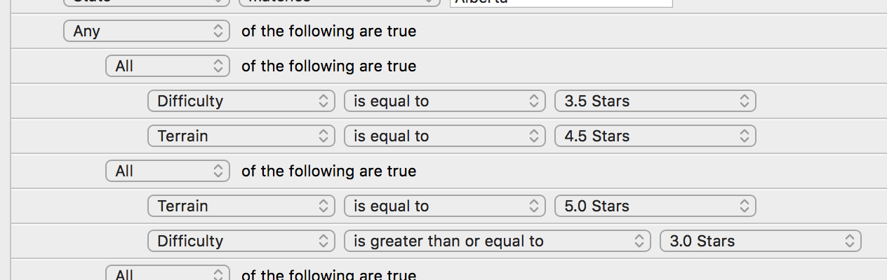
From an end user perspective I saw two way to have this implemented: automatic or manual. From the back end, it is just like ChrisDem said, a consecutive application of D/T filters all OR-ed together. In the automatic mode, Cachly would be able to look at my online profile (as quoted earlier) and grab the data from the current D/T matrix. No need to keep all finds within Cachly. The user would have to provide the "loop number", which is the minimum amount of caches for each D/T combination. The matrix is then processed and each combination that has less finds than the "loop number" becomes an OR condition in the SELECT statement. In the "manual" mode the user would provide a list of D/T combinations that should be filtered on. A specification in the form of 9x9 checkboxes would be sufficient for that. That's if this is implemented as a single "filter". In iCaching it is possible to add multiple D/T combinations in a filter: In this screenshot all caches that are either 3.5/4.5 or 5/3 .. 5/5 are selected. While this is full flexibility, it becomes more difficult to see what is included. The 9x9 checkboxes make things much clearer. Again, I don't think the back-end is very difficult, the largest amount of time might be in the usability. That is not an argument in favour of this request but I hope this clears things up a bit.

-
I'm using iCaching but even there, with the elaborate filtering options, it is quite time consuming. Project-gc is the easiest by far but as I don't have a premium membership for that site (can't really justify it for just this feature) it becomes less helpful if there is only a single DT that I need for the next loop. If I was running Windows I might have just done this in GSAK but I'm in a pure Apple environment so iCaching is the next best thing for me. What ChrisDen describes is my option 1. which works but it is slow AND it takes up the highlight flag so I can't use it for something else. I agree it is somewhat of a special case but Cachly has changed my workflow a bit as well. With the speed and easy of getting caches in an area and exporting that to a GPX file, I no longer create pocket queries. Instead I get the caches in Cachly and export to GPX file to load onto the GPS. All the new functionality for filtering that was added in version 3 make Cachly really useful for me and it now replaced Geosphere as a standard tool. Plus I see more people completing their Fizzy and continuing to work on the next loop. From that perspective (and because feature requests are actually considered) I put in this request. If nobody has the same request it will sink down to the bottom anyway. There is no harm in asking :-)
-
I support this request. Doing a lot of earth caches in Paris while only looking at the offline data meant I had to skip a few because I could not see the pictures that the questions were referring to.
-
I usually log to drafts which I then edit on the computer before logging the cache. The log in the field is just to record the time the cache was found. So my workflow for "in the field" logging is: hit the "Log this Cache" button hit the "Save" button This brings me right back to the cache screen and if I then don't hit the "back" button to look at the map, but just turn off the phone and go to the next cache, it is not always clear that a cache has been logged. Sure, there is this small checkmark on the cache but with the green of a "traditional" icon and the green checkmark it is not always clear. Perhaps it is my age. Perhaps a clearer (or bigger) icon for the "is logged" state can be added, or perhaps after logging go back to the map view?
-
Whenever I'm in a new area, I try to focus on those caches that will help me get the next loop of my DT grid. Sometimes I use project-gc for this but since I don't have a premium membership for this site, I'm limited to the next loop while my goal is a few loops away. As a work around I've tried two things: Note which combinations are missing from my DT goal and create a filter for each missing goal. I then highlight all the filtered caches to mark them. Once I've manually gone through all combinations, the highlighted caches are the ones I would need to get. Create a separate program that looks at my online DT stats and loads a GPX file. It then adds a UserFlag to those caches that would satisfy a missing DT combination. Upon loading that modified GPX file into Cachly, the highlighted caches again note the ones I should get. Both of these options are time consuming, require an internet connection and tie up the UserFlag field. I would love to have a filter that either shows me the caches that have the missing DT combinations for the n-th round. The current DT matrix could preferably be taken from my profile or manually entered on for instance a grid with checkboxes.
-
 Nic Hubbard reacted to a post in a topic:
Export GPX has control characters
Nic Hubbard reacted to a post in a topic:
Export GPX has control characters
-
I'm exporting about 2000 caches from a region in the Netherlands and noticed that my Garmin GPS62s only picks up a fraction of the caches. I tried to import the exported GPX in geosphere where I encounter an error. The error message says there are control characters in the description. The cache that had control characters (GC4C3D8) indeed had a ^X and a ^Y in the description. Exporting the GPX file from the geocaching.com website didn't produce the ^X and ^Y characters. After I removed the control characters from that cache, the ones in the same series and another cache (that had ^B among other characters), all 2000 caches loaded fine in my Garmin and in Geosphere. Could the export option automatically filter out possibly offending characters?