ferda-mravenec
-
Posts
38 -
Joined
-
Last visited
-
Days Won
3
Everything posted by ferda-mravenec
-
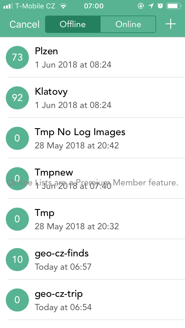
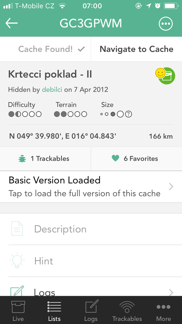
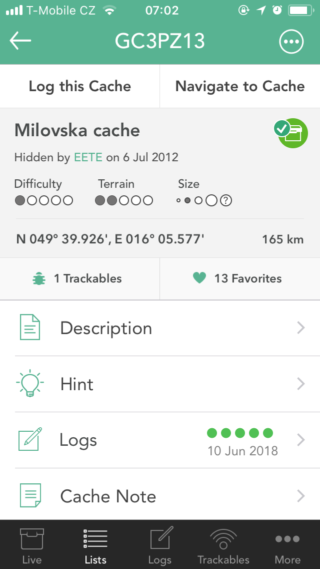
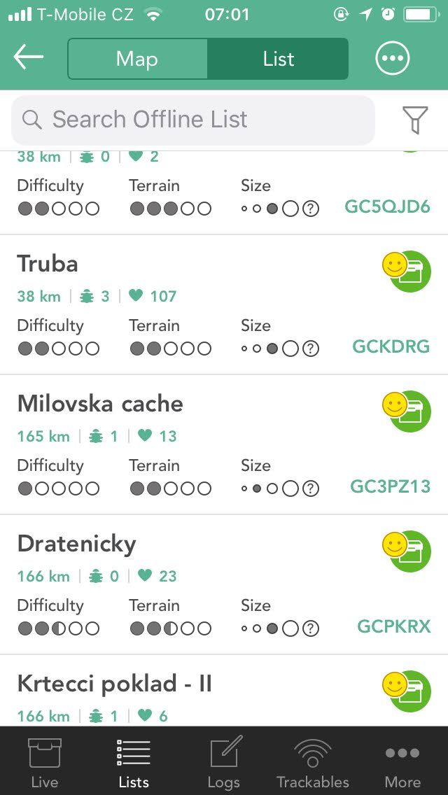
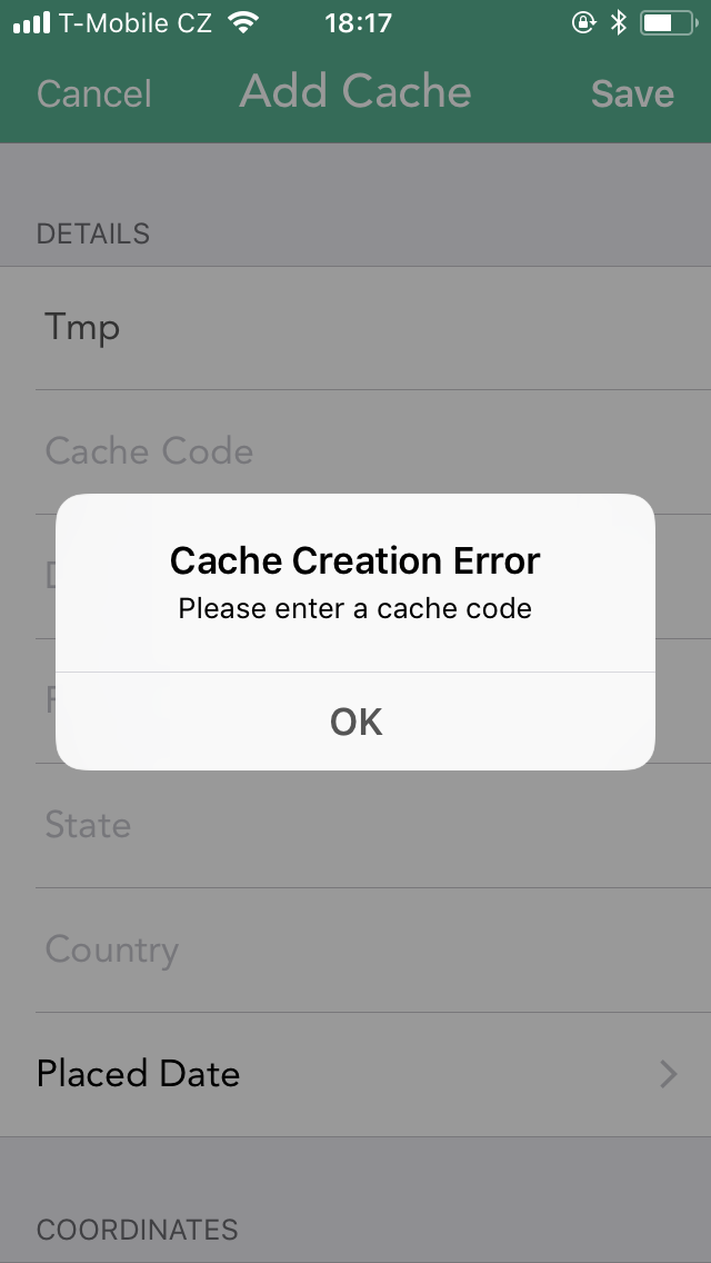
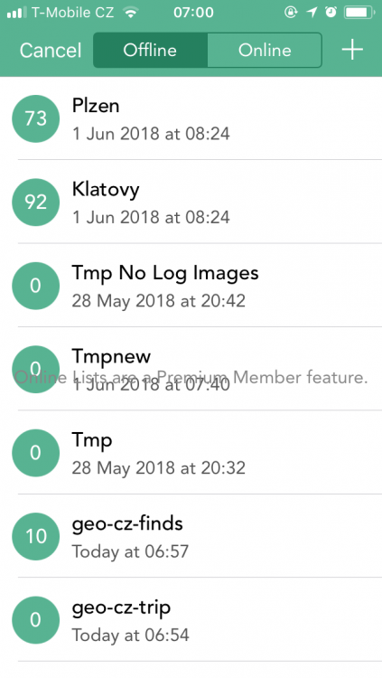
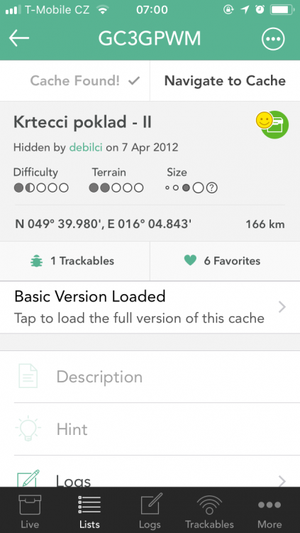
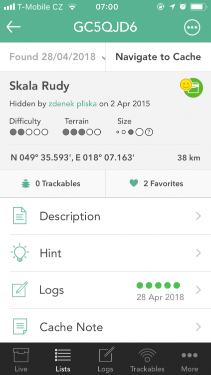
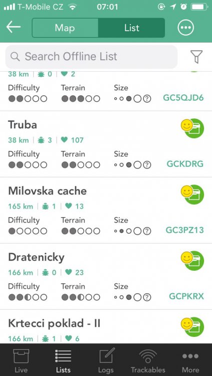
Hello @Nic Hubbard. I have just downloaded new version of Cachly and here are my thoughts. Onine list tab is useless for basic members. Would it be possible to hide the tab if currently logged in user is not a premium meber? Online list tab message leaks to Offline list tab In a different threadyou mentioned, that there will be an option to "Move filtered Caches" in v4.3. But there is no such an option available. Dunno whether following are related to v4.3.1: For some found caches, I see "Cache Found!" label, for some "Found *date*" and for some "Log this Cache" even though all the caches have been logged through Cachly. Please note, that "Milovska cahe" is highlighted with smile icon indicating that I found the cache, but once I open the cache, there is nothing about my find. Once I want to see the log from a particular cache, I open the cache and click "Cache Found" button (or whatever it currently displays) and new screen opens with "Log Cache". This is not intuitive because one can think it will navigate him/her to the log he/she submitted. What about keeping the button the same label "Log this Cache" and add next clickable row with "Own Logs" to the cache detail (somewhere above "Logs") which will display all own logs? Anyway I am happy you are still adding new features and making the app better. Thank you.

-
GPX namespaces supported by Cachly
ferda-mravenec replied to ferda-mravenec's topic in General Questions
Hi @Nic Hubbard. Cachly behaves weird. Sometimes, the trackable icon is clickable and I can see tackables' details and sometines not. Wht's the magic behind it? How does Cachly load log entries' images? I have following: <gsak:LogImages> <gsak:LogImage> <gsak:ilogid> 749135221 </gsak:ilogid> <gsak:iguid> 9207b0d8-3c0d-4baa-b554-eb82f14da261 </gsak:iguid> <gsak:iimage> https://img.geocaching.com/cache/large/9207b0d8-3c0d-4baa-b554-eb82f14da261.jpg </gsak:iimage> </gsak:LogImage> </gsak:LogImages> But Cachly doesnt parse it. Cachly loads log images only when I swipe down on Logs screen to refresh logs. Would it be great if it load images while parsing GPX. Well, A lot of unexpected behaviors is happening while loading GPX files. You noted, that hundreds GPX files have been tested, but still Cachly ignores some well-known elements. Please, provide the list of supported elements to us. Thank you. -
GPX namespaces supported by Cachly
ferda-mravenec replied to ferda-mravenec's topic in General Questions
Hello. 1) I found no way how to import Country field into Cachly. Following has no effect: <groundspeak:country> Czechia </groundspeak:country> 2) I thought that trackable counter within cache's detail screen is clickable. But looks like it's not for: <groundspeak:travelbugs> <groundspeak:travelbug id="3398882" ref="TB43WK9"> <groundspeak:name> Bimbo der Elefant </groundspeak:name> </groundspeak:travelbug> </groundspeak:travelbugs> The whole GPX file: <gpx version="1.1" creator="xxx" xmlns="http://www.topografix.com/GPX/1/1" xmlns:groundspeak="http://www.groundspeak.com/cache/1/0/1" xmlns:gsak="http://www.gsak.net/xmlv1/6"> <metadata> <author> xxx </author> <time> 2018-05-26T14:36:24Z </time> </metadata> <wpt lat="49.905883333333335" lon="18.3362"> <time> 2016-11-21T00:00:00Z </time> <name> GC6X9DW </name> <desc> Rybena </desc> <link> <href> https://coord.info/GC6X9DW </href> <text> Rybena </text> </link> <sym> Geocache </sym> <type> Geocache|Traditional Cache </type> <groundspeak:cache id="5973233" available="true" archived="false"> <groundspeak:name> Rybena </groundspeak:name> <groundspeak:placed_by> waalter </groundspeak:placed_by> <groundspeak:owner> waalter </groundspeak:owner> <groundspeak:type> Traditional Cache </groundspeak:type> <groundspeak:container> Small </groundspeak:container> <groundspeak:attributes> <groundspeak:attribute id="14" inc="0"/> <groundspeak:attribute id="24" inc="0"/> <groundspeak:attribute id="64" inc="0"/> <groundspeak:attribute id="6" inc="1"/> <groundspeak:attribute id="19" inc="1"/> <groundspeak:attribute id="32" inc="1"/> <groundspeak:attribute id="39" inc="1"/> <groundspeak:attribute id="40" inc="1"/> </groundspeak:attributes> <groundspeak:difficulty> 2.0 </groundspeak:difficulty> <groundspeak:terrain> 2.5 </groundspeak:terrain> <groundspeak:country> Czechia </groundspeak:country> <groundspeak:state> Moravskoslezský kraj </groundspeak:state> <groundspeak:short_description html="true"> PROSIM, CHOVEJTE SE NENAPADNE, MÍSTO JE NEKDY PREMUDLENO AUTY! A ZAROVEN DBEJTE NA TO ABY KRABICKA VYDRZELA CO NEJDELE, NEBYLO ZROVNA NEJJEDNODUŠŠÍ UDĚLAT! <p style="text-align:justify;">Moc informací neexistuje ohledně pobočky Rybeny v Bohumíně. Tudíž listing je obecný k tomuto závodu a informace se spise tykají hlavního sídla, které se nacházelo v Kovářské poblíž Chomutova. Bohumínská pobočka byla podobna hlavnímu závodu, jen v menším měřítku.</p> </groundspeak:short_description> <groundspeak:long_description html="true"> <p style="text-align:justify;">Postavení, jež bylo naprosto bezkonkurenční v regionu a jedinečné v celé republice, si vydobyla firma na rybí konzervy Antonína Kally z Kovářské, založena r. 1910.<br /> <br /> Mořské ryby ze Švédska dodávali obchodníci z Hamburku po železnici většinou přes hraniční přechod ve Vejprtech. V Kovářské je pak zpracovávali na mnoho způsobů. V rosolu a marinádě, do rybích salátů nebo jako uzenáče a pečenáče. Továrna měla 32 udících boxů, sklady na syrovou cibuli a nakládanou zeleninu, vlastní výrobnu octa, jehož spotřebovali přes dvacet tisíc litrů měsíčně.<br /> <br /> Zpracované lahůdky se expedovaly většinou v plechovkách, vyráběných přímo v závodě. Z odstřižků, příliš malých na zhotovení konzerv, se dělaly buď plechovky menších rozměrů a jiné výrobky z kovů. Stejně racionálně, promyšleně a úsporně se zacházelo i s odpadem z ryb. Voda, kterou se po vykostění ryby čistily a umývaly, se shromažďovala ve zvláštních nádržích, zbylá odpadní voda se využívala jako hnojivo na pole. Kosti z ryb se sušily a rozemílaly na rybí moučku.<br /> <br /> V roce 1921 otevřela firma zahraniční filiálku v rumunském Temešváru. Měla pobočku i v <strong>Bohumíně</strong>, ta vznikla v roce 1923, kde její hlavní činnosti bylo zpracování mořských a sladkovodních ryb a s tím související výroba rybích výrobků a polotovarů. Podnik fungoval až do konce roku 1992.<br /> <br /> Dnes je v areálu mnoho soukromníku a různých podnikatelů s různým zaměřením. Jediné co dnes připomíná tento podnik je autobusová zastávka Bohumín/Pudlov – Rybena.<br /> <br /> </p> </groundspeak:long_description> <groundspeak:encoded_hints> Použijte HINT - fotografie.<oe>Na strome v úrovni oci. </groundspeak:encoded_hints> <groundspeak:logs> <groundspeak:log id="769297274"> <groundspeak:date> 2018-05-20T00:00:00Z </groundspeak:date> <groundspeak:type> Found it </groundspeak:type> <groundspeak:finder id="1787395"> HakyCZ </groundspeak:finder> <groundspeak:text encoded="False"> Je to spousta let, co jsem tu skoro každý den jezdil. A ´pamatuji, jak jsme tam jezdili pro ryby a díky některým dobrým konexím i pro takové, které moc v obchodech nebyly:-))) ...holt staré dobré časy.-))) Je moc dobře, že tahle keš mladým připomene, že i v tady takový závod kdysi byl. Moc pěkná krabička a je v pořádku. Díky a TNLN </groundspeak:text> </groundspeak:log> <groundspeak:log id="768574811"> <groundspeak:date> 2018-05-18T00:00:00Z </groundspeak:date> <groundspeak:type> Found it </groundspeak:type> <groundspeak:finder id="22668946"> Pindruše712 </groundspeak:finder> <groundspeak:text encoded="False"> Počasí se nám po včerejšku umoudřilo tak jsme si odpoledne zajeli s FCB1922 na menší geovýlet do Bohumína.Hned první keška nás pobavila,protože jsme si mohli ulovit rybu na stromĕ.To se jen tak každému nepodaří.Dĕkuji moc za pĕknou kešku. </groundspeak:text> </groundspeak:log> </groundspeak:logs> <groundspeak:travelbugs> <groundspeak:travelbug id="3398882" ref="TB43WK9"> <groundspeak:name> Bimbo der Elefant </groundspeak:name> </groundspeak:travelbug> </groundspeak:travelbugs> </groundspeak:cache> <gsak:wptExtension> <gsak:Watch> false </gsak:Watch> <gsak:Found> false </gsak:Found> <gsak:IsPremium> false </gsak:IsPremium> <gsak:FavPoints> 32 </gsak:FavPoints> <gsak:Guid> 8614b2a5-0c3e-4468-8ff6-8176e068da58 </gsak:Guid> <gsak:CacheImages> <gsak:CacheImage> <gsak:iname> Areál - Dnes </gsak:iname> <gsak:iguid> 26aa575b-c88f-42db-8245-1479204e5d74 </gsak:iguid> <gsak:iimage> https://img.geocaching.com/cache/large/26aa575b-c88f-42db-8245-1479204e5d74.png </gsak:iimage> </gsak:CacheImage> <gsak:CacheImage> <gsak:iname> Hint </gsak:iname> <gsak:idescription> Nejlepší cesta :-) </gsak:idescription> <gsak:iguid> bf002c2f-20e7-47a9-ba67-4faed04a7e46 </gsak:iguid> <gsak:iimage> https://img.geocaching.com/cache/large/bf002c2f-20e7-47a9-ba67-4faed04a7e46.png </gsak:iimage> </gsak:CacheImage> </gsak:CacheImages> </gsak:wptExtension> </wpt> </gpx> Thank you for your help. -
Themes for offline maps; Move filtered caches; POI support
ferda-mravenec replied to ferda-mravenec's question in Feature Requests
Ah, ok. so still have to fill it up. Will try it with my scenario. Finger crossed for future, future, future release Thank for reply. -
GPX namespaces supported by Cachly
ferda-mravenec replied to ferda-mravenec's topic in General Questions
Great, thank you for your reply! -
Themes for offline maps; Move filtered caches; POI support
ferda-mravenec replied to ferda-mravenec's question in Feature Requests
@rragan No sir. Have you tried it yourself? Required fields are: Cache name, cache code, cache type. And this is far from POI not related to Geocaching.. @Nic Hubbard In that case, would it be possible to to somehow link Saved locations with offline lists? So I can display them all at once?
-
Themes for offline maps; Move filtered caches; POI support
ferda-mravenec replied to ferda-mravenec's question in Feature Requests
I know, but I am not talking about caches. I would like to create a POI without providing Cache code, Placed by username, Difficulty, and so on. Just simple POI without geocaching metadata. -
Hi there. Is there any list of supported namespaces for imported GPX files? I am creating a tool which will export geocaches' metadata into GPX file and I would like to know which elements I am able to use. Like GPX v1.0, v1.1. Groundspeak's v1.0, v1.0.1, and so on. Thank you.
-
Themes for offline maps; Move filtered caches; POI support
ferda-mravenec replied to ferda-mravenec's question in Feature Requests
Great!! Thank you! Something like Saved Locations, but with a bit more features, the features not tied to geocaching only. So I can easily create new List of points and each point will have name, location, note, picture, icon, etc. So I can display them all (or based on filter) within a map. Basicaly they will be GPX waypoints. -
Themes for offline maps; Move filtered caches; POI support
ferda-mravenec posted a question in Feature Requests
Hello. While using the app, I am missing some usefull features I was used to on Android platform. Themes for offline vector maps (discussed here: http://www.cach.ly/support/index.php?/topic/915-custom-offline-maps/) Support for moving filtered caches. Now if I apply a filter to a list of caches, there is an option to "Delete Filtered Caches" only. I am used to gather all "Found it" caches in one separate list, so it will be great if there will be an option to "Move Filtered Caches" as well. Support for POI. While travelling, I was creating POIs at some interresting points with a note, a picture etc. Would it be possible to add support for POIs? Thank you. -
@Nic Hubbard Hi. For sure, take a look at Czech Republic, for example N 49° 38.672', E 18° 35.550'. There are planty of bike trails shown within online map but not in offline map. Offline maps also misses hill shades and contour lines. Please, add support for themes for offline maps!
-
Yop, I have. Bike trails are colored in non-offline mode (Open Maps - Open Cycle) only. But this is useles if you are out of the signal and can not use online maps. One way could be to download a bit more information along the map itself and to implement theme support for offline usage. Finger crossed for themes Thanks.
-
Hello Nic. Any news regarding this feature? I am asking as a hiker. Currently there is no way to display colored hiking trails, cycling trails, hill shades and/or contour lines. So it is impossible find a proper way to hunt any mountain cache down. Along this request could be a request for 3rd party themes for vector maps. Custom offline vector maps/themes could be top feature of the app. PS: maybe downloaded vector map contains such an information like I mentione above, but the theme used inside the app doesn't show them? Is there any limitation why this feature is not possible to implement? Thanks, Ferda