

elrojo14
-
Posts
40 -
Joined
-
Last visited
-
Days Won
4
elrojo14's Achievements
")
Newbie (1/14)
2
Reputation
-
Oh and I forgot. He set it up to where it scanned the cache page so you did not have to even input anything. Oh well. One can dream.
-
I was just listening to the Geocaching Podcast last night and one of the Android app designers made a Reverse Wherigo Solver and is about to publish it in their app. Nic, can you throw in a Reverse Wherigo Solver? That would be pretty sweet. And before anyone accuses me of being lazy, the sheer fact reverse wherigos exist confirms anyone who hides one is lazy. We would just be returning the favor! And by the way, I own like 150 reverse wherigos! LOL.
-
Thank you for fixing that. I think I will wait until the next PQ I download to try it again and see if the issue is resolved. I have nothing I need to download right this second. Thank you.
-
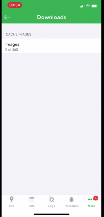
I stayed on the downloads screen and nothing happened. When I ran that PQ into a list again, the Images now shows 0 of 5466!!! So it appears even more blocked up than it was before. So the question is how can we cancel or delete a downloading images and the bigger question for you is how do we get this working again?
-
I created it using the PQ Query in GC.com and then used the Cachly PQ tab to make a new offline list. https://www.dropbox.com/s/ueonsl35wjcqsn0/23619512_KRV500.zip?dl=0 I am trying a redownload now to see if that helps.
-
I downloaded a PQ last week and for some reason the images never downloaded. I am not sure if I was supposed to leave it on that screen until it was finished or what. Either way, I can go back to that screen now and nothing is happening. However, there is a red notification on my downloads tab and you know how annoying that can be. Here is a video of what I am talking about. https://www.dropbox.com/s/yde8fr49nlc19w1/AGAG0489.MP4?dl=0 I will upload a photo as well. I have it just sitting on that screen now and will see if it starts downloading after a couple of minutes. Nothing so far.
-
Great advice. Thanks!
-
I wonder how some of the now expired apps we no longer have access to were able to access the information. I have found work arounds so it isn't the end of the world and as someone else said, the people wanting to use this are probably not very many. Oh well. Thank you.
-
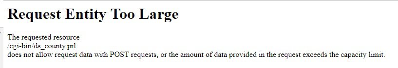
I just tried to download my county and man it is taking forever. I suppose some counties in the US are larger or smaller than others. Mine is pretty large. In fact, it finally got there and then when I tried to select them all it gave me this image below.
-
Any progress on making a benchmarking API from Cachly? Many would that be wonderful.
-
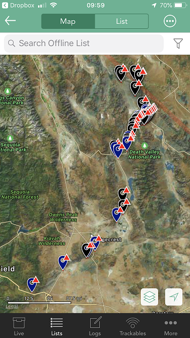
Our Death Valley trip was cancelled due to the government shutdown, but we changed our Geocaching plans and found six fun benchmarks that hadn't been found in years. How could we tell? They were buried under an inch or two of dirt and moss. Cachly performed wonderfully. I sent my .gpx file to Tung8 and while I drove, he read the description and I snuck a peak at the map and where we were at. When we got close enough, we focused on the descriptions. The only thing is we saved the benchmarks as finds when we were done, but those won't upload to Geocaching for probably good reason and even the .txt file screws it all up. Which isn't a huge deal because I usually know what benchmarks I found by looking at my photos on my phone since I take photos of each one I find. Cachly is certainly a great option for those of you wanting to do paperless benchmarking where you don't have reception. If we can get it to do live benchmarking support, that would be awesome!
-
I just used the NGS site to find a bunch of datasheets and PIDS I needed to create some .txt files that I converted to .gpx and upload them to Cachly for my Death Valley run next weekend. That part is now working wonderfully. No doubt about it, Cachly has solved my offline benchmarking problems and I now can do full on paperless benchmarking anywhere. I would love to see this improved though where maybe it could also save the Geocaching benchmark logs and data along with photos and of course see Cachly do real time benchmark displays. There are not a ton of benchmarkers out there, but hands down if Cachly supported them fully, they would definitely buy Cachly.
-
Nic, is this something you can ask your contacts at Groundspeak about? Let them know you are interested in possibly using Cachly for benchmarking and asking them if it is possible?
-
 elrojo14 changed their profile photo
 -
It has to be. Now I think the findbenchmarks.com gives you all of the benchmarks, not just the ones that are on the Geocaching snap shot they took in 2000. Which, I could always get over if I found a few that I couldn't log on Geocaching.com.
-
So do you think the findacontrol used USGS data then to make its database? How did they list them and show them on a map?
